The Friends of Blue and Fairview Lake through the Environmental
Protection Agency (EPA) Technical Assistance Grant (TAG) program
contracted with Portland State University faculty and staff to
provide an independent review of the groundwater contamination
problem at the Boeing-Cascade site in East Multnomah County. An
independent consultant, Karann Brandt, of PRC Environmental Management,
Inc., was also assisting the panel with the review.
The region of groundwater contamination is a 2.5 square mile region
bounded by NE Halsey Blvd. to the Columbia River and NE 178th
to NE 223rd (see Figure 1). The groundwater contamination
is primarily of volatile organic compounds (like trichloroethylene
or TCE). The approximate plume extent is shown in Figure 2 in
one of the principal aquifers, the Troutdale Sandstone Aquifer
(TSA).
Figure 1 Study area showing Fairview Lake and Blue Lake.
Since the Interlachen community in the area of Blue and Fairview
Lakes uses groundwater as a community water supply and the lakes
as a recreation resource, there are concerns that the groundwater
contamination could seriously affect the community by contaminating
their water supply and surface water bodies (Fairview Lake, Blue
Lake, Columbia Slough) in their vicinity. Much work has been accomplished
already by responsible parties (Boeing and Cascade Corporations
and their consultants), the State of Oregon Department of Environmental
Quality, and the Portland Water Bureau and its
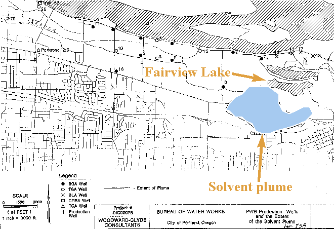
Figure 2 Schematic of TCE plume in the Troutdale Sandstone Aquifer (Woodward-Clyde).
consultants. The community was able to secure the EPA TAG to provide
an independent review of the contamination problem facing their
community and to assist the community in understanding the nature
of the contamination problem. Issues of concern identified from
this review will be recommended for incorporation in the Department
of Environmental Quality's (DEQ) final Record of Decision concerning
site remediation efforts. This review will help assure remediation
strategies that protect groundwater and surface water for the
Interlachen community will be pursued by the responsible parties.
Risks to the community can be itemized as follows:
These issues will be explored by the review panel and recommendations
made to minimize risk from the groundwater contamination in their
community.
1.2 Philosophy of the Panel Review
The primary focus of the panel was to
Some of the questions examined included:
The products from this panel review include this report, non-technical
oriented facts and issues papers for the community, and a response
to the Oregon DEQ's Record-of-Decision which is scheduled for
release on September 1, 1996.
At Portland State University this review is being conducted by
faculty from Civil Engineering, Geology, and Environmental Sciences
and Resources. These faculty have expertise in the following areas:
groundwater contamination transport and modeling, groundwater
geology, geologic stratigraphy, surface water contamination transport,
and environmental toxicology. The independent consultant has degrees
in Biology and Civil Engineering and has experience in contamination
assessment, risk management, and remedial action design.
The study area includes several industrial facilities which have
been involved, to varying degrees, in the investigation and cleanup
activities associated with the groundwater contamination. Investigations
have primarily centered around Boeing of Portland, located at
19000 NE Sandy Boulevard, and Cascade Corporation, located at
2201 NE 201st Avenue, both in Troutdale, Oregon. Boeing began
contamination assessment activities in 1986, after closure activities
associated with a rinsate (see Glossary) impoundment
revealed excessive levels of contaminants (such as chlorinated
solvents and petroleum products) in groundwater monitoring wells.
Cascade initiated investigations on their property in 1988 after
the decommissioning of two waste coolant underground storage tanks
(USTs) revealed contamination in soil and groundwater of chlorinated
solvents. Since 1993, these two companies,
under a Consent Order from DEQ, have been working together to
address the groundwater contamination. The following is a discussion
of the history of each facility.
2.1 Boeing of Portland
In 1963, the first manufacturing building, 85-001, was constructed
by Electronic Specialty Company, a major subcontractor to The
Boeing Company at the time. Aerial photographs taken prior to
1963 indicate that the area was primarily agricultural farmland.
The property and building were occupied by several aerospace and
electronic parts manufacturing companies from 1964 to 1974. During
this time, the property had various owners and was divided into
numerous parcels. In 1969 Electronic Specialty Company was acquired
by International Controls Corporation, which in turn transferred
the Portland plant to a Boeing subsidiary, Radiation International,
Inc. (Boeing, 1988)
In 1974 Boeing leased the facility and began to purchase the property
parcel by parcel. Other manufacturing companies subleased the
west portion of the main building from 1971 to 1985. By 1979 Boeing
was the sole owner of the facility property and improvements.
In 1979 and 1980, Boeing constructed a wastewater pre-treatment
plant, employee recreation areas, and building 85-105, used for
parts assembly and storage.
From 1981 to 1984, Boeing utilized a surface impoundment for the
temporary storage of rinsate from electroplating and metal finishing
operations prior to transfer to the waste water treatment plant.
Both the pre-treatment plant and impoundment were located directly
west of building 85-001. Upon closure of the impoundment in 1985,
a Detection Monitoring Program was implemented as required by
DEQ. Six groundwater monitoring wells, installed around the perimeter
of the impoundment, were monitored for six consecutive quarters,
from January, 1986 to July, 1987. Groundwater was found to be
contaminated with high levels of trichloroethylene (TCE), 1,1,1-trichloroethane
(TCA), and methyl ethyl ketone (MEK). The monitoring program revealed
that other point sources were suspected due to the elevated levels
of contaminants detected in upgradient monitoring wells. (Landau,
1988)
Upon reviewing the interim monitoring results, DEQ initiated a
monitoring program of the surrounding water supply wells and Boeing
extended their monitoring to onsite water supply wells in an attempt
to define the extent of contamination. Consequently, additional
investigations were conducted to identify the source, nature,
and extent of contamination on the site.
Reviews of historic aerial photos, interviews with Boeing employees
and officials, and visual inspections of the Boeing facility property
revealed numerous areas of chemical storage, historic waste disposal,
and stressed vegetation which may have been areas of solvent spills,
indicating contaminant releases. (Landau, 1986)
2.2 Cascade Corporation
The Cascade facility was constructed from 1955 to 1956 for the
purpose of manufacturing forklift truck attachments. At that time
the facility included a waterfall paint booth, a parts assembly
area, a maintenance shop, an assembly area for hydraulic cylinders,
two underground storage tanks (USTs) for gasoline storage, and
offices. In 1961, Cascade installed a vapor degreaser near the
hydraulic assembly area for the purpose of cleaning metal parts
with TCE. The degreaser was used continuously until 1975 when
it was removed , and TCE usage was discontinued. (EMCON, 1993)
Operations expanded to include nickel and chrome electroplating
in 1963. Chrome and nickel plating operations were discontinued
in 1978, but nickel plating was resumed from 1982 through 1986.
(EMCON, 1993)
In 1966, another facility expansion included carburizing of forklift
attachments which continued until 1985, when carburizing was replaced
by purchasing tempered steel.
In 1971, two underground storage tanks were installed northwest
of the production facility to store waste coolant and oils. Cascade
installed a cutting bin drainage system in 1979 that collected
coolant lubricant drippings from metal cuttings for transfer to
the waste coolant tanks. The waste coolant tanks and cutting bin
drainage system were decommissioned in 1988 under the supervision
of DEQ. At that time, approximately 50 cubic yards of contaminated
soil was removed and disposed of at an off site facility. In fall
of the same year Cascade received a Consent Order from DEQ to
conduct additional investigations into the nature and extent of
contamination. (EMCON, 1995)
3.1 Boeing of Portland
As reported by Boeing, three processes at the facility utilized
solvents: vapor degreasing, manual parts cleaning, and painting.
Vapor degreasing is the process of dipping parts into a tank of
solvent vapor to remove oil, grease, and metal particles. TCE
was used as a vapor solvent from 1974 until 1980, when it was
replaced by TCA. Manual parts cleaning used a 50-50 mixture of
toluene and methyl ethyl ketone (MEK) until 1984, when another
50-50 mixture consisting of half MEK and half TCA was used. Painting
operations use Toluene as a paint thinner, BMS-11-7B as a cleaner
prior to painting. (Boeing, 1986)
Although records of chemical use are unavailable for the earlier
years at the facility, it is assumed the operations and raw materials
were the same for the previous tenants. In 1985, the use of solvents
was recorded to be: 8,600 gallons of TCA in the degreaser and
for manual cleaning; 600 gallons of MEK/TCA mixture; 181 gallons
of Toluene and 900 gallons of BMS-11-7B which is a mixture of
aromatic naptha, ethyl acetate, MEK, and isopropyl alcohol. (Boeing,
1986)
Five areas have been identified as primary sources of solvent
contamination. All of the areas were included in additional soil
and groundwater investigations to determine the nature and extent
of contamination. However, no single source was identified as
the primary source of groundwater contamination.
East Yard: This area is located at the southeast corner
of building 85-001 and has been the primary location for material
handling since 1968. A subsurface soil investigation revealed
4,670 parts per billion (ppb) of TCA at 12 feet below the ground
surface. (Landau, 1988)
East Area: From 1968 to 1972 liquid waste was disposed
along this long strip of land located 400 feet south of the East
Yard area. This area may have been completely excavated during
the excavation and construction of building 85-105. (Landau, 1988)
Central Area: Occasional waste disposal occurred from 1964
to 1967 along a 350-foot wide area south of building 85-001. (Landau,
1988)
West Area: This area is located 200 feet west and 400 feet
north of the southwest corner of building 85-001. Liquid disposal
is suspected to have occurred here from 1966 to 1972. (Landau,
1988)
Vapor Degreasers: A degreasing facility was formerly located
at the northwest corner of building 85-001 from 1964 to 1968.
It was believed to have leaked on at least one occasion, but soil
excavation during later construction removed much of the shallow
soil contamination. (Landau, 1988)
Although originally suspected as sources, the surface impoundment
and TCA storage tank were determined not to be significant sources
based on subsurface investigations.
3.2 Cascade Corporation
Six areas have been identified as known or suspected sources of
TGA contamination at the Cascade site. All of the areas in the
immediate vicinity of the main manufacturing building and, with
the exception of the north ditch source area, are covered by pavement
or building structures.
Of the six areas identified (see Figure 3), only the first three
are suspected of being long term source areas for groundwater
contamination, with the first being the most significant.
Area 1: Former Waste Coolant underground storage tanks
(USTs): This area includes the former UST nest, a cutting
bin storage area formerly connected to the USTs, the cutting bin
drainage collection system, and the area of a former storage shed.
The USTs were used from 1971 to 1988 for spent water-based machinery
coolants and waste oils. Reports were made of two accidental overflows
of TCE waste from the USTs in the 1970's and of small TCE spills
just outside the tank nest. (EMCON, 1996)
Degreaser waste was also reported to have been dumped in a small
ditch adjacent to a storage shed near the UST nest. This ditch
has also been identified as the source for contaminants within
the North Ditch source area.
This area has been considered to be the primary source of TCE,
its breakdown products, and petroleum hydrocarbons in the soil
and groundwater, based on the concentrations detected. In addition
to occasional spills and dumping, water runoff from the cutting
bins and stormwater flooding of the drainage collection system
also contributed to impacting the soil, groundwater, and the North
Ditch source area. Recent monitoring at wells in this area have
revealed significant levels of light non-aqueous phase liquid
(LNAPL).
Area 2: Former Vapor Degreaser: A vapor degreaser, formerly
located in the northwest portion of the production facility, is
believed to be another source of contaminants in the groundwater.
In addition to small spills and drips of TCE in the area, large
discharges of TCE have been reported by former Cascade employees.
On at least two occasions prior to the 1964 facility expansion,
waste liquid from the degreasers was pumped directly onto the
ground (EMCON, 1996). High contaminant concentrations in soil
and groundwater to the north and west of the degreasers corroborate
the historical information.
Area 3: Former Chrome Plating Facility: A chrome plating
facility formerly located on the west end of the production plant
was utilized from 1964 until 1978. It is suspected this area was
a source of chromium and PCE due to the presence of elevated concentrations
of both contaminants in the soil and groundwater in the area.
PCE concentrations in the groundwater near the former chrome plating
facility are 10 to 100 times higher than elsewhere on the Cascade
site, indicating an independent source. (EMCON, 1996)
Area 4: North Ditch: The ditch, located on the north side
of the facility property, receives stormwater runoff from the
site. Impacts to the ditch are probably related to releases from
the former cutting bin drainage system and overflows of the drainage
collection sump conveyed by stormwater runoff. Other impacts may
be related to degreaser waste disposal near the former storage
shed and waste coolant USTs. Contaminants detected in the area
include TCE, cis-1,2-DCE, PCE, acetone, chloroform, toluene, ethylbenzene,
and chromium. Infiltration of surface water through soil in the
ditch may have contributed to impacts to groundwater. (EMCON,
1996)
Area 5: Hydraulic Line Trench: Elevated levels of TCA,
TCE, and Total Petroleum Hydrocarbon (TPH) have been detected
in soils near the hydraulic line trench inside the southern portion
of the production facility. Structural supports near the area
of contamination have restricted the removal of much of the soil.
The trench was lined with a concrete containment in 1990. (EMCON,
1996).
Area 6: Vapor Degreaser Sludge and Coolant Disposal: Historical
information indicates that occasional disposal of vapor degreaser
sludge occurred up to 1970, near the former west end of the parking
lot and outside the northwest corner of the facility (EMCON, 1996).
Coolant was also reported to be disposed of on the ground northwest
of the production facility. Investigations have indicated that
contamination was limited to shallow soils.
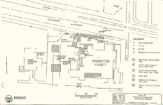
Figure 3. Cascade Corporation site.
The Interlachen neighborhood consists of approximately 150 households
which rely on groundwater produced from four wells in the area.
The Lachenview well is located north of Fairview Lake, at the
east end of the Interlachen community. This well, screened from
130 to 168 feet below the ground surface, is the only well which
draws groundwater from the Troutdale Sandstone Aquifer (TSA).
The Interlachen well (220 ft deep), screened from 201 to 216 feet
below the ground surface, is located north of Fairview Lake, at
the center of the neighborhood. The West Interlachen well, located
north of Fairview Lake at the west end of the Interlachen community,
is 261 feet deep. Both the Interlachen and West Interlachen wells
draw groundwater from the Sand and Gravel Aquifer (SGA).
Blue Lake Water Coop serves about 12 houses from the Blue Lake
Aquifer on the North side of Blue Lake.
The well pumps are usually operated in phases such that two of
the three wells are utilized at the same time. Although the pumps
are not equipped with continual reading flow meters, water usage
has been estimated to be 1500-gallons per household, per week
during the winter. Water use in the summer can be expected to
be two times higher.
All four wells are currently operated by separate, independent
water systems. A proposal has been made to unify the water systems
into one public utility district owned and operated by the Interlachen
community.
The Lachenview well, located the farthest from the migrating contaminant
plume, is monitored by the City of Portland Water Bureau. The
City collects water samples periodically and analyzes the samples
for TCE and tetrachloroethylene (PCE).
The following compounds are Chemicals of Concern (COC) for groundwater
(not for the soil phase). Chlorinated solvents, such as PCE and
TCE, have discrete degradation pathways. The commonly accepted
pathway for PCE is as follows:
PCE TCE trans-1,2 DCE and cis-1,2 DCE 1,1 DCE Vinyl chloride CO2
The following is a description of each COC identified in groundwater
at the project site.
Tetrachloroethylene (PCE)
PCE is a common chlorinated solvent used in industry for the removal
of grease and oil. Concentrations of PCE in on-site and off-site
test borings have ranged from 55 ppb to 210 ppb. PCE has been
detected in 52% of groundwater samples and 5% of surface water
samples, with most detections exceeding the Maximum Concentration
Level (MCL) of 5 ppb. (EMCON, 1996)
Trichloroethylene (TCE)
TCE , also a chlorinated solvent, was used by Cascade from 1961
to 1975 in the vapor degreasers to clean metal parts. TCE is also
a degradation product of tetrachloroethylene (PCE). TCE has been
detected at the highest frequency of any chemical and at elevated
concentrations, both on and off-site in groundwater. Concentrations
have been detected as high as 24,000 ppb in groundwater and 5,500
ppb in soil at a test boring located near the former waste coolant
USTs. TCE has been detected in 79% of groundwater samples and
69% of surface water samples. (EMCON, 1996)
Cis-1,2-dichloroethene (DCE)
DCE, a degradation product of TCE, has been detected in 71% of
groundwater samples and 60% of surface water samples. TCE concentrations
frequently exceed MCL for drinking water (70 ppb) with the highest
levels reaching 13,000 ppb in TGA groundwater. DCE has been detected
in surface springs as well. (EMCON, 1996)
Vinyl chloride
Vinyl chloride, the most toxic of the degradation products of
PCE and TCE, has been detected in 11% of groundwater samples,
frequently above the MCL of 2 ppb (EMCON, 1996). Vinyl chloride
has been found to be restricted to the area around the former
waste coolant USTs and has not been detected at Shepard or Taggart
Springs.
Chromium
Chromium, a heavy metal with an MCL of 100 ppb, has been found
in 13% of groundwater samples and in the soil at elevated concentrations
(1,430 ppm) near the former Cascade chrome plating plant (EMCON,
1996). Sludge waste disposal areas were also found to contain
detectable levels. The chrome plating plant was operational from
approximately 1963 to 1978. Neither Shepard Spring nor Taggart
Spring has been impacted by chromium.
Manganese
Manganese, a heavy metal, has been found in 41% of groundwater
samples, primarily in areas where Volatile Organic Compounds (VOCs)
have been detected. (EMCON, 1996)
Other Compounds
Additional volatile organic compounds such as trichloroethylene
(TCA), methyl ethyl ketone (MEK), and Toluene were used extensively
on-site but have not been classified as COCs since these are based
only on groundwater and not soil concentrations.
Various surface water bodies exist within the study area or are
direct discharge points from the TSA or other drainage pathways
from the study area (see Figure 4). Many, but not all, of the
water bodies have been included in water quality or sediment analyses.
Taggart Spring and Shepard Spring
Taggart Spring and Shepard Spring discharge from the TGA north
of I-84 and the Cascade facility at a flow of less than 30 gpm
and 5 gpm respectively (EMCON, 1995). Taggart Spring eventually
flows into Storm Drain Creek and into the Columbia Slough. Shepard
Spring discharges to the TSA approximately 250-feet north of the
spring emergent point. TCE and 1,2-DCE have been detected in both
springs.
Storm Drain Creek and East Ditch
Storm Drain Creek is a tributary to the Columbia Slough located
north of the Boeing facility. Water in the creek consists primarily
of storm sewer runoff, groundwater from the extraction system
discharge from RPW-2 at Boeing, and from Taggart Spring. No TSA
connection has been identified at Storm Drain Creek.
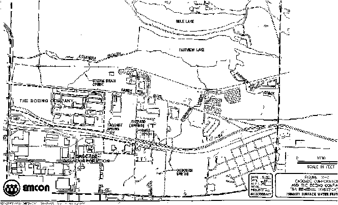
Figure 4 Surface water features in vicinity of groundwater contamination (EMCON, 1995).
East Ditch is located east of the Cascade facility and extends
north under I-84 to Osbourn Creek. Runoff from Cascade and NE
201st Avenue discharges into the ditch.
Fairview Creek and Osbourn Creek
Fairview Creek flows north where it drains into the southeast
corner of Fairview Lake. METRO (1994) has performed some basic
water quality analyses of Fairview Creek evaluating eutrophication
problems.
Osbourn Creek is fed by Osbourn Spring which is located east of
NE 205th Avenue and south of I-84. Osbourn Spring discharges from
the TGA. Osbourn Creek discharges to Fairview Lake at the south
shore, approximately at the middle of the lake. The creek was
sampled once in 1993, in two different locations along the creek,
revealing non-detectable levels of contaminants-of-concern (see
Section 4). (EMCON, 1995)
Both Fairview and Osbourn Creeks are fast moving streams containing
cold water species such as cutthroat and rainbow trout and both
are discharge points for the TSA.
Fairview Lake and Blue Lake
Fairview Lake, located at the north side of the study area, is
approximately 65 acres in area and reported to be four feet deep
in the summer, and contains warm water game fish such as large
mouth bass. The lake has been reported to be hydrologically connected
to the TSA along the south shore to a certain degree. Water levels
are controlled by a levee at the west end of the lake which discharges
water to the Columbia Slough. The lock is managed by the Multnomah
Drainage District. Much of the water entering the lake is stormwater
drainage from the cities of Fairview and Gresham. Water in the
lake was sampled in two different locations, 600 feet and 1600
feet west of Osbourn Creek, in March, 1993 (EMCON, 1995). Results
revealed non-detectable levels of contaminants-of-concern (see
Section 4).
A study by METRO (1994) concluded that the water quality of inflows
to Fairview Lake (e.g., from Fairview Creek ) were not improved
by the Lake.
Blue Lake, located north of Fairview Lake, has a similar surface
area, but is much deeper. The lake has a direct connection to
the Blue Lake Aquifer (BLA) and possibly to the TSA along the
south shore. Due to its depth, Blue Lake contains species such
as large mouth bass, carp, blue gill, green sunfish, black and
white crappie, brown bullhead catfish, and is stocked with rainbow
trout and winter steelhead.
Columbia Slough
Columbia Slough, located 1,500 feet north of the Boeing facility,
is the ultimate receiving water body for much of the study area.
The TSA also discharges to the Slough. The Slough is included
in the City of Portland's Sediment Sampling Program, and has been
included in a quarterly water quality monitoring program. Trace
amounts of TCE (1.5 ppb) have been detected in water samples as
recently as August, 1994. (EMCON, 1995)
The geology of the study area in the vicinity of the plume can
be considered complex. Figure 5 shows a typical geologic cross-section
going approximately South to North from the Cascade area through
Fairview Lake, Blue Lake, and the Columbia River. Figure 6 shows
a geologic cross section through the Portland well-field going
West to East parallel to the Columbia River. The predominant geologic
units present are: TGA (Troutdale Gravel Aquifer), TSA (Troutdale
Sandstone Aquifer), CU1 (Confining Unit 1), CU2 (Confining Unit
2), and the BLA (Blue Lake Aquifer). [See also Figure 7 showing
these geologic units.] The following reviews were prepared to
critique and review the geologic assumptions made by consultants
involved in determining the character and nature of the groundwater
pollution problem.
Figure 5 Typical cross-section through study area showing geologic strata.
Figure 6 Geologic Strata in the Portland Wellfield area.
All of the sediments and sedimentary rocks underlying the Fairview
Lake area are fluvial deposits of the Columbia River deposited
on top of the Columbia River Basalt Group lava flows in the past
15 million years. The upper 500 feet of this statigraphic section
probably ranges in age from four million years, the uppermost
part of the Sand and Gravel Aquifer (SGA), to 12,000 years, the
unconsolidated Missoula flood sediments.
River deposits tend to range from coarse gravel deposited in the
high-energy channel to fine silts deposited during flooding on
the shallow flood plains. The shape of fluvial deposits may be
tabular in the flood plains to highly lenticular for the channel
deposits of sand and gravel. Since the river's course does not
remain in a fixed position over time, especially in an alluviating
basin, the positions of sand bars and channel gravels migrate
laterally as the sedimentary deposit thickens and earlier deposited
flood plains may be dissected by flood channels or channel migration.
Therefore, the stratigraphy of a fluvial system, like the Columbia
River, tends to be complex, laterally variable, and quite difficult
to predict and model. Sometimes the best that one can do is to
group the deposits into the more permeable beds that are dominantly
sand and gravel, representing the channel deposits, and the less
permeable beds that are dominantly sand to clay sized sediment,
representing the overbank deposits. The Fairview Lake area is
basically made up of these kinds of deposits, but is further complicated
by a history of periodic rapid deposition of vitric/lithic sand
produced by interaction between lava flows and the river and later
modification by catastrophic erosion and then deposition by the
Pleistocene Missoula floods.
Geologic History
A brief geologic history summary of the various stratigraphic layers in the study area are provided to help to better understand the hydrogeologic units and predict their characteristics in ground water contaminant migration.
 Figure 7 Geologic strata
in the contamination area.
Figure 7 Geologic strata
in the contamination area.
Sand and Gravel Aquifer (SGA)
The SGA was created by channel deposits of the Columbia River
during slow subsidence of the Portland Basin while the river channel
remained near its present position. The presence of a small percentage
of exotic metamorphic and plutonic clasts and abundant quartz
and mica grains in addition to the dominant basaltic cobbles,
indicate that the Columbia River transported some of its load
from distant headwater locations in Canada, Idaho, and Montana.
The sand lenses are arkosic and poorly cemented so that the permeability
of the entire sand and gravel aquifer is uniformly high. Most
of the overbank, flood plain deposits at this time were located
south and west where they are generally identified as the Sandy
River Mudstone. The Sandy River Mudstone is micaeous and its mineral
and chemical composition strongly indicates its Columbia River
source, and also occurs north of the present Columbia River in
Washington.
A vitric/lithic sandstone occurs near the top of the SGA, indicating
that small volcanic vents located in the Cascade Range along the
Columbia River had begun to erupt basaltic lava, some of which
flowed into the river, chilled and fragmented to form glass sand
that was carried down the river and deposited in delta-like beds
into the Portland Basin. These beds are almost instantaneous deposits
and were initially probably nearly continuous near the Columbia
River channel, thinning rapidly westward and onto the flood plain
to the south.
Confining Units 1 and 2 (CU1 & CU2)
The abrupt addition of large volumes of vitric/lithic sand to
the river resulted in rapid sedimentation along the Columbia River
channel in the Cascade Range and into the Portland Basin which
alluviated the channel producing a braided stream and forced the
river to new courses throughout the Portland Basin and covered
the Sandy River Mudstone with coarser Columbia River channel deposits.
The relative positions of river channel and flood plain made radical
shifts during this time of episodic volcanic eruptions so the
Fairview Lake area alternated between low permeability overbank
silts (CU1 & CU2) to high permeability channel sands and gravel
(TSA). The channel deposits during this time alternated between
vitric/lithic sands during episodic volcanic eruptions that flowed
into the river, upstream, and gravels containing exotic clasts,
the normal load of the Columbia River. Radiometric dating of these
basaltic centers along the Columbia River range from 3.7 million
years to less than 1 million years. These confining units should
be thought of as leaky aquitards (See Glossary). It is quite possible
that they have been breached by channel cutting in places.
Troutdale Sandstone Aquifer (TSA)
The TSA actually comprises two layers, both of which are fairly
permeable, that are grouped together as the TSA. The lower third
of this unit is dominantly conglomerate and the upper two-thirds
is vitric sandstone. This is the thickest vitric sandstone in
the section, ranging over 100 feet. It is a product of volcanic
eruptions of basaltic lava flows that poured into the large Columbia
River, chilled and shattered to form huge amounts of glass sand.
This glass sand was then carried down stream and deposited within
the river channel until it was filled and then spread out onto
the flood plains forming a wedge-shaped delta into the Portland
Basin. The glass sand was rapidly buried and cut off from the
atmosphere, as is suggested by its still black, glassy appearance
in the drill holes. Where exposed at the surface, as in the ridge
between Fairview Lake and Blue Lake, it takes on a brown oxidized
coloration due to iron present in the rock particles. This unit
is considered sandstone and is traditionally made of glass and
rock particles and is thought to thin rapidly to the west and
south. The upper part of the TSA contains vitric sand interfingering
with the finer silts of CU1. Because of its mode of origin, the
volume of sand in the bed, and rapid deposition the TSA may well
be the most continuous unit in this area.
Troutdale Gravel Aquifer (TGA)
The Troutdale Gravel Aquifer media is similar to the gravels present
in the lower section except it contains a greater proportion of
Cascadian clasts (largely andesite) and are often less well cemented.
The presence of the clasts from Cascadian volcanoes is due to
a fairly rapid uplift of the Cascade Range in northern Oregon
in the past 2 to 3 million years and the incision of the Columbia
River and tributary streams during this time. In addition, these
events were probably accompanied by the eruptions of Cascadian
stratovolcanoes, which also contributed to the presence of these
clasts.
Blue Lake Aquifer (BLA)
In the last 2 to 3 million years the Cascade Range in northern
Oregon has been uplifting as streams were rapidly incising their
channels. The Portland Basin also appears to have been rising
but at a much slower rate as portions of the earlier sedimentary
deposits of the valley were eroding. Interglacial rises in sea
level during the Pleistocene epoch may have temporarily resulted
in terrace deposits. Near the end of the Pleistocene epoch, cataclysmic
floods repeatedly occurred as glacial Lake Missoula was first
filled and then violently drained. Up to 100 floods poured through
the Portland Basin from about 15,000 to 12,000 years ago that
dramatically accelerated the erosional and depositional processes
in the Portland Basin. Each flood first scoured channels as it
passed through the basin and then deposited gravels (ranging in
size up to 10+ ft boulders near the mouth of the Gorge) along
the course of the river and finer sediments in the back water
areas. Missoula floods were the likely cause of the channel into
which the BLA was then deposited. The flood gravels are similar
to other gravels in the area except that they contain some very
large boulders, and they form a very open framework gravel that
is unconsolidated and largely devoid of the finer grained matrix
due to the very high energy of the flood waters. These gravels
are the most permeable in the area.
Cautions for hydrologic analysis
1. Assumptions of uniformity (homogeneity) are optimistic. There
are many lens-shaped beds and very few of the smaller beds can
be projected with any confidence from drill hole to drill hole.
This applies to both the aquifers and aquitards. The TSA is clearly
described as composed of two different lithologies even though
their hydrologic characteristics may be similar.
2. The determination of the presence or absence of faults and
folds in these rocks is very difficult without considerable exposure
or numerous drill holes. The use of small scale units to make
such determinations is usually suspect. The vitric sands may offer
the best chance of correlation because they are the result of
an individual eruption that sent lava into the river and therefore
are uniform in chemical composition, which is characteristic of
that deposit. Also it is deposited almost instantaneously (in
a geological sense) over a fairly broad area of channels and floodplains.
Geologic Analysis
The Troutdale Formation in the area of concern is characterized
by rapid lateral and vertical variations that reflect the complex
dynamics of the Columbia River as it passed from the Columbia
Gorge into the Portland basin. Depending on sediment supply, subsidence
rates in the basin, volcanic activity in the Cascade Range, and
uplift rates in the Cascades Range the depositional system probably
varied between prograding fan or fan delta and braided stream
system. Displacement of one sedimentary environment by another
as channels shifted across the fan or braided stream complex produces
sediment geometry that is difficult to predict. At a gross scale,
stratigraphic units are recognized if contacts are defined by
general criteria such as "point in the stratigraphic sequence
below which lithology becomes predominantly conglomerate".
Such a statement does not preclude conglomerate from being present
above that point, but does indicate that conglomerate becomes
predominant below that point. At a more detailed scale, it is
highly unlikely that thin units can be traced laterally. In addition
to rapid lateral and vertical facies successions, erosional and
weathering surfaces are expected to be present. The prominence
of such features depends upon the length of time a particular
set of conditions persisted in the depositional basin. The differences
in grain size in different sedimentary environments results in
differential compaction. Fine-grained sediments are more likely
to undergo greater compaction than associated coarse-grained deposits.
Areas where channels persisted for considerable lengths of time
may occur at shallow depths in the modern setting relative to
the contemporary flood plain deposits. Differential compaction
may produce variations in depth of an inter-unit contact.
Associated with the development of weathering and erosion surfaces,
it is likely that the water table changed elevation through time.
The fluctuation of the water table encourages degradation of chemically
unstable constituents in the sediments. Basalt glass, a chemically
unstable and reactive constituent, is likely to be altered during
alternating wetting and drying. Alteration of basalt glass to
clay minerals and iron oxides and oxyhydroxides releases chemical
constituents to the ground water. Mineral precipitation, especially
silica phases, zeolites, and carbonate minerals, is likely to
occur wherever fluids of differing composition interact. These
zones of fluid mixing are likely areas for cementation and result
in reduction of porosity.
The following comments require consideration in developing ground
water models and predicting contaminant transport in the study
area.
1) Investigations of the characteristics of confining units have
treated lithology as laterally continuous. Given the characteristics
of the depositional model, such an assumption appears to be difficult
to support. Lateral continuity of thin lithologies is not likely.
2) An evaluation of the constraints placed on ground water models
by lithologic variations in confining layers is generally lacking.
Since the confining layers are viewed as important in restricting
the movement of contaminants between aquifers, such an evaluation
is important. The spatial variability of lithology in hydrologic
units and how this variability impacts ground water models needs
to be rigorously assessed. How sensitive are the models to variations
in the hydrologic parameters induced by lithologic variations?
3) The abundance and mineralogy of secondary precipitated phases
(cements) and the extent of alteration of primary basalt glass
in stratigraphic units needs to be evaluated in light of the ability
of secondary minerals to reduce porosity and provide adsorption
sites for contaminants. Location of paleo water tables and weathering
horizons need to be assessed in relation to cementation and variations
in hydrologic properties.
4) The distribution of secondary precipitated phases and alteration
of primary basalt glass needs to be assessed in the vicinity of
the erosional surface that cuts deeply into the TSA and how these
phases relate to the development of the ground-water mound needs
to be evaluated.
5) The distribution of stratigraphic units in the area of concern
may be explained by either structural development or by differential
compaction and distribution of sedimentary facies. The structural
interpretation is presently used to explain these patterns. However,
a model based on stratigraphic concepts needs to be developed.
The distribution of lithologies and unconformities in the two
different approaches has implications for developing ground water
models and how water may move within the deposits. Distinctions
between units defined by lithologic characteristics must be clearly
distinguished from those defined by hydrologic characteristics.
The East Multnomah County (EMC) groundwater models consist of
a groundwater flow model and a contaminant transport model. The
flow model was originally developed by Papadopulos for DEQ and
was later modified and revised by EMCON and Landau for the Boeing
company and the Cascade Corporation. The transport model was developed
by EMCON/Landau for Boeing and Cascade. Based on the limited information
presented in the model reports, the contaminant transport model
in its present form is conceptually problematic and can not be
reliably used to predict the future spreading and impacts of EMC
groundwater contamination. The following bullet points are a summary
and specific comments on some of the questionable model assumptions
and their potential impacts on the conclusions obtained from the
Boeing/Cascade groundwater model study.
The Boeing/Cascade transport model predicts that the SGA is presently
not contaminated and, under large scale City
of Portland (COP) pumping, a TCE plume may develop in 20
years but the maximum concentration is less than the MCL. The
currently observed TCE hits in the SGA were attributed to possible
cross-contamination from well bore leakage.
It must be stressed, however, that the Boeing/Cascade groundwater
model implicitly assumes that flow and transport within each of
the aquifer layers is essentially horizontal and two dimensional.
Vertical variations in the aquifer head and contaminant concentration
within the layer are not modeled, although the interaction and
variation among the layers are taken into account. This two-dimensionality
assumption is acceptable if we are only interested in the general
flow pattern since the flow in the EMC aquifers on a large scale
is essentially horizontal. The assumption, however, is inadequate
where vertical flow is significant as in the groundwater mound
area, in the discharge areas near the surface water features and
the partially penetrating pumping wells, and in the area where
the confining units CU1 and CU2 are thin. The two-dimensionality
assumption is flawed for contaminant transport in the SGA and
the BLA since the plumes, if they exist, in these aquifers are
inherently three-dimensional and the contamination are far from
vertically mixed. The transport model predicts vertically averaged
concentration within each aquifer layer. The results are not meaningful
and can be misleading unless the plume fills the whole aquifer
thickness. This is not the case in the SGA. The contaminant concentration
immediately below the CU2 at the top of the SGA can be much higher
than the predicted vertical average. Therefore, the Boeing/Cascade
transport model in its present form may grossly under-predict
the potential SGA contamination, especially under large scale
SGA pumping.
The Boeing/Cascade transport model predicts that, under non-pumping
condition, the TSA plume will be mostly captured by surface features
and, under large scale COP pumping, may reach
the well fields in approximately 20 years.
It is important to stress that the transport plume model assumes
that groundwater flow is steady and ignores a potentially important
transport mechanism: dispersion, or plume spreading due to spatial
and temporal variability in groundwater velocity caused by small-scale
geological heterogeneity, intermittent pumping, tidal and seasonal
groundwater level fluctuations. Simple "order of magnitude"
analyses (based on a typical dispersion coefficient for a plume
of the observed scale) shows that the TSA plume front may migrate
much faster when dispersion is taken into account (especially
during large scale COP pumping) and
may reach the well fields significantly sooner than what is presently
predicted.
The grid size adopted in the groundwater model is 330 ft by 330
ft in the detailed model area and 1000 ft by 1000 ft elsewhere
in the regional model area. Such a grid size can not adequately
resolve the detailed land and surface water features that dictate
the detailed local flow pattern in the area of critical concern.
And, the coarse grid is insufficient in resolving the rapidly
varying concentration plume distribution. Although further grid
refinement may not change materially the general large scale flow
pattern, it may affect contaminant particle tracking and transport
modeling significantly. Particle tracking is often sensitive to
even a small change in the curvature of head contours. Predicted
concentration from a coarse grid plume transport model can be
artificially diluted since the predicted concentration represents
the concentration averaged over a discrete model cell volume (averaged
horizontally over a 330 ft by 330 ft area and vertically over
the complete aquifer thickness). Note management decisions and
especially risk assessment are often made based on the maximum
concentration that can be significantly higher than the predicted
mean concentration from the transport model.
The groundwater flow model appears to significantly over-predict
the TSA drawdown in response to the 1994 BLA pumping. Boeing/Cascade
deemed the model conservative and thus acceptable despite the
discrepancy. However, it should be stressed, that such a model
is not necessarily conservative when used to predict the rate
of migration of the TSA plume. This all depends on what actually
causes the discrepancy. For example, the exaggerated TSA drawdown,
if caused by an underestimate of the TSA permeability, would lead
to a reduced groundwater velocity and thus slow down plume migration.
This is not conservative. On the other hand, the overestimate
of the TSA drawdown, if caused by an underestimate of the TSA
thickness, would lead to an increased groundwater velocity and
thus a conservative prediction of the rate of plume migration.
The Boeing/Cascade groundwater model predicts that, under non-pumping
conditions, the TSA contamination plume will be mostly captured
by surface features. The validity of this conclusion depends on
the aquifer and surface water connection. At the EMC site, this
connection is largely controlled by the thickness and hydraulic
characteristics of the sediment materials that lie at the bottom
of the surface water bodies. Mathematically, this is characterized
by the so called "leakance" coefficient. The selection
of these leakance values is crucial in accurately simulating the
impacts of these surface features on the plume migration.
In the present groundwater flow model, the leakance values are
selected based on the hydraulic conductivity and thickness of
the TSA. This may not be always correct. The surface features
in the detailed model area are mostly underlain by the less permeable
overbank sediments not indirect contact with the TSA. As a result,
the actual leakance value may be significantly lower than those
used in the model. The leakance can also be significantly affected
by the degree of siltation at the bottom of the surface water
bodies and the degree of penetration of these surface features
into the aquifer layers. The best way to obtain an estimate of
the effective leakance values is to calibrate the flow model to
the hydrographs that explicitly reflect surface water and groundwater
interaction. Graphical and quantitative comparison of the predicted
and observed time hydrographs (not just the mean or heads at a
particular time) in the proximity of the different surface water
features can provide a significantly more accurate and unique
calibration than the simple steady calibration or transient calibration
at a particular time used in the present Boeing/Cascade groundwater
model.
In the Boeing/Cascade groundwater flow model, the surface water
bodies are represented as head dependent recharge/discharge cells.
Flux between surface water and groundwater is calculated as the
product of the leakance and the head difference between the surface
water and the underlying aquifer layer. However, these same surface
water bodies were also simulated to receive direct recharge from
precipitation and surface drainage. This is wrong because such
a representation results in double counting of the surface water
recharge! The contribution to recharge from precipitation and
surface drainage in the surface water areas are already implicitly
reflected in the surface water level. This incorrect representation
may impact the detailed flow pattern in the proximity of the surface
features and the surface water and plume interaction. According
to the EMC flow model sensitivity analysis reported by Papadopulos,
natural recharge appears to be by far the most sensitive parameter
in controlling aquifer level and flow pattern at the site under
non-pumping conditions.
Based on the Boeing/Cascade steady flow model, the predicted aquifer
level in the neighborhood of Blue Lake seems to be always smaller
than the Blue Lake level. This indicates that Blue Lake discharges
water to the adjacent aquifers. Where does the water in the Blue
lake come from? Does the lake have a large enough surface drainage
system that feeds and maintains the water level in the lake? How
can one then explain the dramatic water quality (turbidity) difference
between the Blue Lake and Fairview Lake?
Model prediction based on limited amount of data is necessarily
uncertain, especially when they are not made full use of. The
aquifer response to large scale pumping as characterized by the
observed transient hydrographs at different wells and surface
water bodies provides crucial information on the field scale aquifer
properties, aquifer-aquifer connections, aquifer-surface water
connections. The shape, the amplitude, timing of the hydrograph
time curves, and the response phase lags in from well to well
and from well to different surface can be all used to infer the
effective aquifer structure. The Boeing/Cascade flow model appears
to be calibrated only to the steady state heads or transient heads
at a particular time. Model parameterization still appears rather
arbitrary. Further transient calibration based on a graphical
comparison of the predicted time hydrographs in all monitoring
wells and piezometers in response to the different large scale
pumping stress in the TSA, SGA and BLA will provide a significantly
more accurate and unique calibration. The detailed calibration
also provides a stringent test as to if indeed the flow model
has reasonably captured the hydrogeology and the temporal and
spatial aquifer dynamics at the EMC site.
Influence of Interlachen Well on Plume Migration
An "order of magnitude" estimate of the influence radius
of one of the Interlachen wells is shown below. The radius of
influence of the well is the distance from the well center where
water is influenced by the pumping of the well. If the plume is
within the vicinity of the radius of influence of the well, the
plume will be influenced by the pumping. If the plume is outside
that radius of influence, the well does not exert an influence
on the plume migration.
Table 1. Zone-of-influence of Interlachen
well.
The calculation is performed based on the following conservative assumptions
Summer time condition:
No rain/recharge
Maximum pumping all from one TSA well
1500-3000 gallons/week/household
150 households
Total pumping rate = 0.064 MGD
No lake recharge
No leakage between TGA/TSA and SGA/TSA
Fully well penetration into TSA
Average TSA thickness = 100 ft
Average horizontal hydraulic conductivity = 50 ft/day
Average storage coefficient = 0.05
Given these values, and based on the theory of well dynamics, the maximum influence radius of the Fairview
well corresponding to 0.5 foot drawdown is on
the order of 100-1000 ft.
Note the influence area represents the outer limit of the cone
of pumping depression. It is different from the zone of contribution
which is the full recharge area that includes the TSA plume area
upgradient. Currently the plume is approximately 2000 ft from
the Interlachen well in the TSA. Given a radius of influence of
1000 ft, the Interlachen well does not currently affect plume
migration.
Evaluation of Papadopulos (1996)
Papadopulos (1996) wrote a report for DEQ to explore several remediation
strategies. These strategies are included in the remediation alternatives
that meet the remedial action objectives, alternatives 4 and 5,
both using groundwater pump and treat technology.
The restoration times estimated based on the travel time analysis were probably overly optimistic.
First, the chlorinated contaminants such as TCE do not always travel as fast as groundwater. This is the well known retardation effect and may increase the cleanup time by a factor approximately 1.5-3, depending on the site condition.
Second, as with most groundwater contamination sites, the EMC site is extremely heterogeneous. The "randomly" distributed small scale spatial heterogeneities, though having little influence on the large scale groundwater travel time, can importantly affect the contaminant transport and transformation. Spatial heterogeneities are often the bottle-neck to remediation efforts.
Low permeability zones trap contaminants, especially those of
lower solubility. Areas of small permeability are often correlated
with areas with high sorptive capacity. Regions of undissolved,
organic liquids (DNAPLs that may flow by gravity through saturated
media to local perched zones and to the bottom the TSA-conglomerate)
and contaminants adsorbed to soil may slowly release contamination
to surrounding groundwater, in effect acting as in situ sources
of contamination and hindering the progress of remediation attempts.
Note the rate of contaminant desorption, because of the "solids
effect", can be much slower than that of adsorption. The
rate of reverse diffusion and desorption may well control the
clean-up time frames.
Failure to recognize this could result in a gross underestimate
of the length of time required to flush contaminants out of the
TSA and TGA and has obvious important implications on remediation
planning, design and cost analysis.
Their estimates would be good if the site is homogeneous, and
the chemicals involved are 100% soluble and conservative. This
is, however, not the case. In fact, heterogeneity, slow desorption
and presence of dense non-aqueous phase liquid, DNAPLs, are the
major reasons why most the pump and treat sites were far from
as successful as predicted.
Recommendation
The present groundwater model does not have the necessary spatial
resolution to address the issues facing the Interlachen community
and the Portland wellfields, especially in the vertical direction.
The present groundwater model did not make effective use of the
available field data especially the large numbers of detailed
hydrographs in response to the large-scale controlled COP
pump tests.
We recommend refining the spatial groundwater model resolution,
especially in the vertical direction, re-calibrate the model to
the observed hydrographs (not just the mean condition or the condition
at a particular time) at different wells in different aquifers
and in surface water bodies in response to the different COP pump
tests, and reevaluate future plume impacts on the COP well fields
and the Interlachen community.
Specific biases of the model:
Some of the "remediation" efforts have included installation
and testing of resource protection wells, evaluation of hydraulic
parameters by pump tests, and continued monitoring in the area.
Source control on-both sites have also been implemented. The remediation
efforts have been focused in the TSA, or in the TGA at each respective
contamination site. The treatment systems that have been implemented
by Boeing and Cascade are itemized below:
Boeing Site:
Cascade Site
Pumping Water to Surface Water Sites
From July 12 through July 21, 1995 the Portland Water Bureau pumped
about 50 million gallons (MG) from the SGA from wells number 4,
6, 7, 9, 11, 16 into the Columbia Slough. The water quality was
extremely poor: dissolved oxygen levels were about zero (even
after 48 hours of pumping) (Ireland, 1995).
 Figure 8. Well location map
(EMCON, 1995).
Figure 8. Well location map
(EMCON, 1995).
The discharge from Boeing to the Columbia Slough from 1991 to
1992 averaged about 225 gpm (0.5 cfs or 0.0142 m3/s). These discharges
have elevated levels of P because "Aqua-Mag" phosphate
was used to control iron fouling on the pump-and-treat system.
The only toxic organic found in the effluent was methylene chloride
at 1.3 ppb and 1.1 ppb for samples taken on 12/4/91 and 9/3/91,
respectively. Samples are collected and analyzed monthly. (Wells
and Berger, 1994). All other VOCs were non-detects. Measurements
of heavy-metals are not performed on the monthly sampling because
heavy metals are not chemicals of concern from the Boeing site.
During 1992 several groundwater wells were checked for metals
by Woodward-Clyde (1994). For well D-12S (owned by Boeing of Portland,
aquifer UG/TGA, unconsolidated gravel,
Troutdale gravel aquifer, located at NE 188th and Sandy),
near the Upper Slough and Fairview Lake, elevated levels of cadmium
(0.0015 mg/l, criteria was 0.0013 mg/l), copper (0.052 mg/l, criteria
was 0.014 mg/l), and lead (0.033 mg/l, criteria was 0.004 mg/l)
were found above drinking water limits (EPA Gold Book values,
1991). Because of heavy metals above drinking water limits from
the wells in the Boeing area, a heavy metal scan is periodically
recommended for the Boeing recharge to the Slough water because
the wells in the vicinity of Boeing show metal contamination.
Alternatives For Future Remediation
TSA Remediation
Remediation objectives have been defined as follows:
The responsible parties have submitted to DEQ a list of alternatives for remedial action. Five alternatives were considered for the TSA cleanup as shown in Table 2.
Table 2. Proposed TSA remediation alternatives by responsible parties.
| Alternative number | Description | Detailed description |
| 1 | no-action | only long-term groundwater monitoring |
| 2 | institutional controls | groundwater monitoring, restrictions on use of TSA groundwater as drinking water supply, provision of alternative water supplies, Portland Water Bureau use restrictions for its production wells |
| 3 | institutional controls and hydraulic control | Alternative 2 + TSA groundwater extraction near plume boundaries, decommission SGA wells that have well-bore leakage; restoration time 100 years |
| 4 | contaminant mass removal and hydraulic control | Alternative 3 + installation of extraction wells in areas of high VOCs, extraction from TSA and/or injection into SGA (rate of pumping: 5 aquifer pore volumes over 60 years); restoration time 50-60 years [DEQ, 1996, estimated that this would be about 85 years to remediate 85% of aquifer to MCLs] |
| 5 | contaminant mass removal and hydraulic control | Alternative 4 + additional extraction wells and increased rate of pumping; restoration time 20 years for 75% of TSA to MCLs [DEQ, 1996, estimated that this would be 24 years to restore 80% of the TSA.] |
Alternatives 4 and 5 include the following 3 design goals:
Where would the extracted groundwater be put? There were 4 ideas:
The issue of where the extracted water is released has largely
been unexplored with regard to heavy metal or other non-VOC contaminants.
This needs further scrutiny, especially if the treated water is
reused in any way that the problem will spread even further.
TGA Remediation Alternatives
The remediation plans have been submitted for the TGA cleanup
at Cascade only. Table 3 shows remediation alternatives proposed
by Cascade for their on-site clean-up. See Figure 3 showing contamination
areas.
Table 3. Proposed TGA remediation alternatives by Cascade.
| Alternative number | Description | Detailed description |
| 1 | continue existing controls and monitoring | continue existing on-site remediation program; 33 years to clean up on-site plume and 14-30 years for off-site plume |
| 2 | soil vapor extraction and passive recovery | Alternative 1 + soil vapor extraction (for unsaturated areas 1, 2, and 3), passive product recovery (for saturated areas - bailers in wells to recover LNAPL in Area 1), and additional source characterization [similar clean-up times as in Alternative 1] |
| 3 | active recovery, air sparging, and groundwater extraction | Alternative 2 + 9 groundwater extraction wells followed by air-stripping, pneumatic skimmers in wells for active LNAPL recovery, air sparging (injection of air into saturated portion of aquifer followed by soil vapor extraction); even though remediation times varied, hydraulic controls were to remain in-place for 30 years |
| 4 | in-situ groundwater remediation | Alternative 3 + bioremediation system (injection of nutrients and oxygen via injection wells); even though remediation times varied, hydraulic controls were to remain in-place for 30 years |
| 5 | soil excavation | Alternative 4 + soil excavation in Area 1 (6200 yd3 to be removed); same remediation time frames as above |
Summary Of Issues With Regard To Remediation Efforts And Plans
The following points can be made about the remediation plans to-date
for the Interlachen community:
Remedial investigations of historical groundwater contamination
have revealed the presence of a number of chlorinated solvents
in groundwater. Toxicological concerns focus on the potential
for these contaminants to affect human populations by exposure
to contaminated water supplies. Additional concerns relate to
exposure of wildlife and aquatic life if groundwater contaminants
impact surface waters.
Chemicals of concern for risk assessment
The principal focus of risk assessment has been on the various
chlorinated solvents and their degradation products that are present
in comparatively high concentrations in groundwater. Limited attention
has been given to inorganic compounds that may also be of concern.
Previous studies have identified more compounds of potential concern
in the TGA than in the TSA, and their is very limited evidence
of contamination in the SGA. Contaminants in the TGA include tetrachloroethylene
(PCE) and trichloroethylene (TCE) and several degradation products.
Evidence of degradation to toxic intermediates is strongest in
the TGA. Production of toxic degradation products is limited for
samples taken from the TSA. In general, these compounds pose potential
human health risks, and the potential ecological effects are of
less concern.
Inorganic contaminants of potential concern in the TGA include
chromium and lead. Copper has been detected in the soil, but the
source of copper in the soils and the lack of dissolved copper
in surface or groundwater is inadequately described. It is unclear
from the various documents if analyses included copper and other
potential toxic metals since reports fail to distinguish between
contaminants that were not detected and contaminants for which
analyses were not done.
Groundwater contamination risk
The risk assessment for the TSA focuses on potential excess cancer
risks for compounds of concern including tetrachloroethylene (PCE),
trichloroethylene (TCE), cis-1,2-dichloroethene, and 1,1-dichloroethene.
The risk assessment is based on conservative human exposure scenarios
for both consumption of contaminated water and inhalation of VOCs
released from water. The compounds examined are known to be present
in the contaminated groundwater, and they pose significant potential
health problems. The risk assessment correctly identifies different
routes of exposure for these volatile organic compounds, including
risks from contaminated drinking water and inhalation risks as
VOCs are liberated from pumped groundwater. Based on the limited
expected exposure of local populations to these compounds, risks
are estimated to be low. Additionally, the nature of the risks
(toxic vs. carcinogenic) remain equivocal, although ATSDR
(1995) suggests that TCE is a probable human carcinogen.
Risk assessments do not fully account for degradation intermediates
that may also be produced. For example, the risk assessment for
contamination in the TSA ignores the potential risk from TCE and
PCE degradation products such as vinyl chloride. Vinyl chloride
has been detected (and assessed) in the TGA but not the TSA. Evaluations
of public health concern by ATSDR identified vinyl chloride, among
other compounds, as posing a risk to public health. Failure to
detect vinyl chloride in the TSA does not mean that it is unlikely
to be present in the future, regardless of which site remediation
action is chosen. The time period for remediation may be sufficient
for vinyl chloride production to occur. Given the probable sorption
of TCE and PCE in the TGA, these compounds have limited mobility.
Degradation products such as 1,2-dichloroethenes and 1,1-dichloroethene
are more mobile, so it is likely that these compounds could be
transported to the TSA. It should be possible to assess the probable
rate of degradation to vinyl chloride in the TSA.
Surface water contamination risk
Surface water contamination by VOCs is expected to pose little
ecological risk. Ecological risks are limited by the comparatively
low toxicity of the chlorinated solvents and degradation products
to aquatic life and wildlife. Human health risks are expected
to be low because of limited contact with contaminants. Potential
contamination of Fairview Lake and the Columbia Slough by the
migrating plume could exacerbate other water quality problems
such as BOD loading.
Chromium contamination of TGA wells has revealed concentrations
as high as 172 ppb. These concentrations would be problematic
for aquatic life if chromium was discharged to surface waters
during remediation activities. There should be concern for enhanced
risk to aquatic life if pump-and-treat systems do not adequately
remove chromium since the acute and chronic water quality criteria
are 16 and 11 ppb, respectively. Similarly, lead concentrations
at Taggart Spring and Sheppard Spring have been measured at levels
exceeding chronic criteria for protection of aquatic life. Given
the evidence of toxic metals at the site, drainage ditches and
discharges could pose additional ecological risks to surface waters
if concentrations of chromium and lead remain near chronic water
quality criteria. Uncertainty is increased by limited monitoring
of some potential sources. For example, the east drainage ditch
at the Cascade site (which feeds into Osborne Creek and then into
Fairview Lake) has been monitored only for VOCs.
Air contamination risk
Soil vapor extraction shows that there are comparatively high
concentrations of vinyl chloride present in the TGA. In addition,
the human health risk models used estimate higher lifetime risks
for inhalation of TCE contaminated water than for direct consumption.
It is problematic to assess the risks of airborne contaminants
at the site, since ambient air monitoring data are lacking. Estimating
risks of airborne contaminants in more difficult that assessing
risks of contaminants in water, yet the proposed remediation activities
and the interim remediation actions continue to release solvents
into the air. It may be possible to estimate ambient air concentrations
and assess whether continued releases pose any significant risks
to workers on site or area residents. Additionally, further estimation
of the rate of degradation of TCE and PCE to a volatile vinyl
chloride intermediate is needed to determine if vinyl chloride
will be a future contaminant of concern. Given that there is evidence
of degradation to vinyl chloride in the TGA and degradation to
intermediates that might be expected to lead to vinyl chloride
in the TSA, some additional attention to risks from vinyl chloride
is warranted.
Soil contamination risk
Contamination of surficial and subsurface soils result in limited,
usually inadvertent, exposure to toxic materials. Soil is not
expected to be a significant source of exposure.
Recommendations
In general, risks of contaminants at the sites are limited unless
the water is used for drinking or bathing. Remediation activities
are needed to assure that contaminant transport is restricted,
thereby minimizing off-site risks, although the present risk to
human populations is low. Assessments of the rate of degradation
of contaminants, uncertain carcinogens (TCE), are needed to determine
if significant concentrations of degradation products such as
vinyl chloride, a known carcinogen, will increase human health
risks over the life of the remediation efforts. Additionally,
the potential for remediation activities to add to the contaminant
load in the ambient air has not been completely assessed and needs
further consideration. Toxic metal contaminants present in TGA
may adversely impact aquatic life in surface waters if the toxic
metals are unmanaged or if remediation activities remove and subsequently
discharge these toxic contaminants to surface waters. The effects
of metals are not adequately represented in discussions of the
remediation efforts, although presently the discharge volumes
and loads are probably very small. Full scale remediation efforts
might present another story, and this could be controlled by permitting.
An overview of the DEQ Draft Record of Decision remediation plan
is presented below for the TGA cleanup at Cascade and the TSA
cleanup at both Beoing and Cascade. The remediation proposal for
the TGA at Boeing has not yet been submitted for review.
Troutdale Sandstone Aquifer
Goals
Recommended Cleanup
The Department of Environmental Quality recommends the alternative
shown below (Alternative 5) including possible variation as described
in DEQ's Alternatives 5A through 6 for the TSA contamination area.
The final configuration of Alternative 5 will be determined during
the remedial design and initial implementation. The goal will
be to improve the cleanup time for Alternative 5 by increasing
the number, location, and extraction rates from those specified
in the preliminary design in the Feasibility Study and/or by adding
re-injection or re-infiltration of treated groundwater to increase
the flushing of contaminants from the aquifer. Figure
9 illustrates potential extraction well locations for the
recommended alternative. The recommended remedy would need to
be designed to meet the following criteria:
Figure 9. Remediation plan for the TSA cleanup (DEQ, 1996).
Cascade Corporation
Goals
Recommended Cleanup
The Department of Environmental Quality recommends the alternative
shown below (Alternative 3) for the cleanup of the soil and TGA
groundwater contamination at the Cascade Corporation site. The
groundwater contamination in the TGA at Cascade is shown in Figure
10. Also, Figure 3 identifies the different Areas mentioned below.
 Figure 10. TSA and TGA contamination
for both the Boeing and the Cascade sites (DEQ, 1996).
Figure 10. TSA and TGA contamination
for both the Boeing and the Cascade sites (DEQ, 1996).
This review has generated a list of concerns for the protection
of both surface and groundwater Fairview and Blue Lake communities.
Several issues were raised after reviewing the Draft Record of
Decision from DEQ released on September 1, 1996.
The following issues were identified by our advisory panel:
Current on-site and off-site remediation of the TGA plume around
Cascade has focused on removal of volatile organic compounds and
their treatment through air-stripping towers. The current and
proposed pump-and-treat systems discharge their effluent, after
air-stripping, to the nearby storm drains that travel to Osbourne
Creek and into Fairview Lake, or into Storm Drain Creek and into
the Upper Columbia Slough. Heavy metals are not monitored even
though the areas of remediation were known to have heavy metal
contamination. There is a need to add heavy metals to the list
of monitoring requirements and to prepare a contingency plan for
removal of heavy metals if found in the effluents. Also, the loading
of heavy metals to Fairview Lake and the Upper Columbia Slough
may be restricted because of the Total Maximum Daily Load (TMDL)
requirements currently being determined by DEQ. The present and
future loading of heavy metals to nearby surface waters should
be estimated, and this information should then be given to the
Columbia Slough TMDL committee for evaluation.
The impact of the proposed remediation plan in the Boeing-Cascade
area has not been formally evaluated by DEQ for inhalation risk
from the air-stripping towers. The proposed remediation plan calls
for dozens and dozens of new pump-and-treat wells, increasing
the magnitude of the remediation effort by from 3 to 10 times
above current levels. Because of the proximity of the treatment
facilities to residential areas, guidelines should be proposed
by DEQ to ensure that there are no air quality risks. DEQ admitted
at a September 4, 1996 public meeting that they have not formally
evaluated the inhalation risk of the remediation plans. The Boeing
TGA remediation plan, which has not been submitted for public
review, also needs to have this level of scrutiny.
A trailer park and residences near the Cascade site have had measurements
of TCE in their drinking water SGA wells. These measurements have
been as high 16 ppb of TCE. The Maximum Contaminant Level (MCL)
for TCE is 5 ppb. Have all the residents who are drinking from
this well been notified by DEQ about the possibility of contamination
and what options they have to reduce the risk of ingestion of
TCE or any of its more toxic by-products, such as vinyl chloride
? DEQ stated at the public meeting on 9/4/96 that SGA wells that
have had "hits" of TCE are self-remediating since any
contamination that seeps from the TSA to the SGA is removed by
pumping from the SGA. If that is true, then DEQ must inform the
residents that by drinking the water and using it, they are capturing
any leakage of TCE from the TSA and removing it from the SGA.
We recommend that wells PMX-195 and PMX-410 be removed from public
consumption and an alternative water supply be provided.
This panel agrees that the proposed remediation plan is a correct approach to solving the groundwater problem in East Multnomah County and wants the implementation to proceed as fast as possible. But a clear plan by DEQ needs to be made as to what will trigger more aggressive remediation techniques. For example, the following questions need to be spelled out clearly in the DEQ Record of Decision:
Before reinjection is attempted, an evaluation of the possible
effects on the sandstone may need to be carried out. The TSA is
made up mostly of sand-sized particles of basaltic glass that
are oxidized when exposed at the surface and might easily be affected
by oxygenated reinjection water. Atmospheric alteration of this
basaltic glass creates clay minerals and palagonite which may
greatly decrease the porosity and permeability of these deposits.
The computer model has flaws that would make its use to formulate management decisions limited. Detailed comments about the model are shown in Section 8. This is of concern if remediation strategies hinge on the reliable prediction of the computer model. The management decisions made by DEQ must carefully show which ones are based on field data and which ones are based on the model predictions. Those that are based on the model predictions need to consider this committee's comments about the weakness of the model and show that the remediation plan would not thereby be impacted. In general,
The DEQ groundwater group needs to make sure that the proposed
remediation plan is a "cradle-to-grave" analysis. The
disposal of the effluent from the treatment systems is assumed
to be discharged into nearby surface waters, ultimately entering
the Columbia Slough. The Columbia Slough is water quality limited
for toxics and nutrients. Any new sources of toxics and nutrients
may not be allowed or may be significantly restricted. The Record
of Decision needs to factor in the cost and impact if effluent
from the remediation pump-and-treat systems are not allowed to
discharge to the Fairview Lake and Slough system.
DEQ stated in its Draft Record of Decision that one objective
of the clean-up was to "allow existing uses of groundwater
in east Multnomah County." This includes allowing the existing
uses of the Interlachen community wellfield. A recent resolution
passed by the City Council on October 23, 1996 stated that the
Water Bureau would attempt to stay within the DEQ pumping limit
of 2.7 billion gallons in the SGA, but that the "DEQ guidelines
would not operate as absolute constraints" if the City deemed
it necessary to exceed those guidelines. If the City violates
guidelines that move the plume and contaminate the SGA aquifer,
not only would the Interlachen community water supply be threatened,
but eventually the City's own well-field would be threatened.
Hence, close cooperation between the City of Portland Water Bureau,
the Responsible Parties, and DEQ are necessary for mitigating
the impacts of the plume and preventing its further spread.
The following terms are used in the report and are defined here
for ease of understanding.
acetone: An intermediate chemical in industrial
processes and used as a solvent for paints and lacquers. In addition
its also used as a cleaning agent and has a comparatively low
acute and chronic toxicity.
acute toxicity: Involving a single exposure which
can elicit toxic effects, immediate effects from a single exposure.
Coming speedily to a crisis, 96 hr. to 4 days
alluvial: Composed of a clay, silt, sand, gravel,
or similar material deposited by a stream or running water.
aquitard: A confining (highly impermeable) bed of
material which retards but does not prevent the flow of water.
arkosic: A mineral rich sandstone, coarsely grained
usually pink or reddish and composed of angular or subangular
grains that may be moderately well sorted.
BLA: Blue Lake aquifer (see Figures 5-7)
BMS-11-7B: metal cleaning solvent; mixture of naptha,
ethyl acetate, MEK, and isopropyl alcohol
brecciated: converted into or characterized by breccia,
a coarse grained clastic rock, composed of angular broken rock
fragments held together by mineral cement, and having sharp edges.
carburizing: A technique to increase the hardness
and strength of a low carbon steel by heating it in a carbonaceous
material environment so the steel can acquire a high carbon surface
layer.
clast: An individual grain or fragment of a sediment
or rock, produced by the mechanical weathering of a larger rock
mass.
chlorinated: compounds containing chlorine
chloroform: A chemical used as a solvent and frequently
used as a dry cleaning spot remover. It can be detected by smell.
chromium: A metal used in electroplating various
parts' surfaces for wear resistance. It is also used in steel
alloys.
chronic toxicity: Consecutive repeated exposure
over the life span of the species resulting in toxic effects,
long term exposure resulting in toxic effects. continuing for
a long period of time, lingering, 30-60 days for which there are
no adverse effects, partial life cycles (less than 15 months)
or whole life cycles.
COC: Chemicals of Concern: chemicals frequently
detected in the TGA or TSA groundwater at concentrations above
MCL and/or which have the potential to be detected at elevated
levels due to degradation pathways of other contaminants
CU1: Confining unit 1, a region of low permeability
material between the TGA and the TSA, see Figures 6 and 7
CU2: Confining unit 2, a region of low permeability
material between the TSA and the SGA, see Figures 6 and 7
1,1 DCA: 1,1 dichloroethane
1,2-DCE: 1,2 dichloroethene
DEQ: State of Oregon Department of Environmental
Quality
DEQ Record of Decision: The Oregon Department of
Environmental Quality's proposed recommendation for cleaning up
the groundwater contamination in East Multnomah County
desorption: Becoming unattached or removed from
a medium either through chemical or physical processes.
DNAPL: dense non-aqueous phase liquid
EMC: East Multnomah County
ethyl benzene: Produced by reforming petroleum fractions
and used in gasoline. It is also a precursor to styrene and is
used with paints as well.
facies: The aspect, appearance and characteristics
of a rock unit, usually reflecting the conditions of its origin,
and used in differentiating the unit from adjacent ones.
feldspar: a group of abundant rocks forming minerals
of formula, MAl(Al,Si)3O8 where M can equal
sodium, potassium, calcium, barium, rubidium, strontium or iron.
leakance: water
leaking from one aquifer into another aquifer through a confining
unit
leaky aquitard: individual beds of silt and clay
which are usually impermeable but have channels cut into them
producing a stratum with permeable spots in it.
lenticular: Resembling in shape the cross section
of a lens, especially of a double convex lens.
lithic: A synonym for lithologic, said of a medium
grained sedimentary rock containing abundant fragments of previously
formed rocks.
lithology: The description of rocks on the basis
of such characteristics as color, mineralogic composition and
grain size.
LNAPL: light non-aqueous phase liquid
Manganese: Allowing agent to improve the strength,
toughness and hardness of steel.
MCL: maximum contaminant level
MEK: methyl ethyl ketone
metamorphic: mineralogical, chemical. or structural
adjustment of rocks due to physical or chemical conditions imposed
at a depth below the surface of weathering and cementation affect
the rocks.
MG: million gallons, MGD million gallons per day
micaeous: consisting of or pertaining to mica; capable
of being split into thin sheets.
P: Phosphorous
palagonite: an altered tachylyte (a volcanic glass
which is normally black, green or brown in color due to abundant
crystalites, and is formed from basaltic magma), brown to yellow
or orange in color and found in pillow lava.
paleo: Denoting the attribute of great age. A prefix
indicating a pre-Tertiary origin, and used to characterize a rock
to a name which it is added.
PCE: tetrachloroethylene
piezometer: An instrument used for measuring the
pressure of a fluid, such as the water level in a confined aquifer.
plutonic: Pertaining to igneous rocks formed at
great depths.
ppb: parts per billion equivalently known as  ,
micrograms per liter.
,
micrograms per liter.
radiometric dating: Calculating the age in years
of geologic materials by measuring the presence of short life
radioactive elements such as Carbon-14.
rinsate:
waste water produced from industrial rinsing and cooling processes
"screened" part of well: location where
water is being withdrawn into the well from the surrounding
aquifer.
SGA: Sand and Gravel Aquifer (see Figures 5-7)
smectite: A name used to describe a specific group
of clay minerals which consist of sodium, potassium, magnesium
or calcium.
sorption: The state or process of gathering or adhering
to a media by adsorption or absorption.
stratigraphy: A branch of geology dealing with the
classification, correlation and interpretation of stratified,
or layered, rocks.
stratovolcanoes: A volcano constructed of alternating
layers of lava and clastic rocks deposits ejected from the volcano.
SU1: siltstone unit 1, geologic description of a
low permeability siltstone unit between the TGA and the TSA, approximately
equivalent to CU1, see Figure ?
SU2: siltstone unit 2, geologic description of a
low permeability siltstone unit between the TSA and SGA, approximately
equivalent to CU2, see Figure ?
tabular: Said of a feature having two dimensions
that are much larger or longer than the third, such as an igneous
dike or a plateau.
TAG: technical assistance grant from EPA
TCA: trichloroethane
TCE: trichloroethylene
tempered steel: heat treating process/technique
to increase the strength and hardness of steel and still have
some ductility.
TGA: Troutdale Gravel Aquifer (see Figures 5-7)
TMDL: total maximum daily load. This is a process
where DEQ allocated waste loadings from point, non-point, and
background sources for water quality limited streams
toulene: A chemical used as a solvent with approximately
2/3 of usage for paints and coatings. It has similar toxicological
affects to benzene.
toxicology: the study of chemicals and their effect
on living organisms, the science of dealing with the effects,
antidotes and detection of poisons.
TPH: Total Petroleum Hydrocarbon
TSA: Troutdale Sandstone Aquifer
UST: underground storage tank
vadose zone: The zone of aeration, a subsurface
zone with water under pressure less than atmospheric including
water held by capillarity and containing air or or other gases.
The zone is bounded on the top by the land surface and in the
bottom by the zone of saturation.
vapor degreaser: device to clean metal parts: the
process consists of dipping parts into a tank of solvent vapors
where oil, grease, and metal particles are removed
vinyl chloride: A polymer created as result of PCE
braking down several times. The direct parent of vinyl chloride
is 1,1 DCE dichloroethene.
vitric: Said of pyroclastic material characteristically
glassy with more than 75% glass.
VOC: volatile organic compounds
weathering: The destructive process by which earthy
and rocky materials on exposure to atmospheric agents change in
color, texture, composition and firmness and results in the physical
disintegration and chemical decomposition of rocks.
zeolites: A generic term for a large group of white
or colorless hydrous alummosilicates (A silicate with alluminum)
that is similar to feldspars with sodium, calcium and potassium.
Citizens of the Troutdale community were asked to submit questions
to the review panel for discussion. These questions are summarized
below with answers provided by the review panel.
1. What is the role of Fairview Lake in terms of its influence
over the Troutdale Sandstone Aquifer (TSA) and the Sand and Gravel
Aquifer (SGA)? Do we need to maintain a large volume of water
(about 102 surface acres) in order to keep a certain amount of
hydraulic pressure that may be related to controlling plume movement?
If there is no connection between the TSA and SGA, the Lake
does not influence plume migration toward the Interlachen wells.
One management alternative is to keep Fairview Lake at a high
elevation in the summer to retard movement of the plume. This
would allow the City of Portland to pump at a higher rate without
moving the plume. This is a controversial issue since the connection
between the lake and the TSA and SGA has not been carefully investigated.
To improve water quality in the surface water, lowering lake levels
and reducing detention time may enhance the quality of the water.
2. How would dredging the lake effect the health, short-term and
long term, of our water supply? What questions about dredging
should we be asking now?
Dredging the lake sediments could have the following results:
removal of toxic material thus restoring the quality of the Lake;
removal of a low permeability barrier between the TSA and Fairview
Lake thus increasing the flow of groundwater into the Lake; removal
of material high in organics and nutrients could improve the trophic
status of the lakes since presently the system is highly eutrophic
(excessive growth of algae and aquatic plants).
3. How do we get adequate scientific PEER REVIEW to help us as
we evaluate the dynamics of our environmental dilemma, i.e., sediment
testing, water quality testing, etc.?
The panel is now providing that service through the EPA TAG
program. But with regard to sediment testing and water quality
testing, from time-to-time duplicate samples of those taken by
other entities can be tested. This expense though would be borne
by the community.
4. What can we do as a community to insure our citizen voice as
we attempt to deal with major corporations, 3 cities, Mult. County,
the Mult. Drainage District, Port of Portland and development
interests while trying to protect our water supply?
Your community has already taken a first step in that direction
by having a technical review panel represent them with DEQ. But
in the future, probably the best way to have a good citizen voice
is to have a well-educated group of citizens. Citizens that are
able to understand and articulate their concerns well can be heard.
The TAG process is hopefully a step in the direction of education
of the community.
5. In what ways is the East Mult. Co. Site (EMC) similar to the
Woburn, Mass. Site involving TCE in 2 local city wells? In what
ways are we different ? Do we have an advantage because our site
has more data available? Is the citizen/local resident able to
grasp the full implication of the EMC site?
In 1990, a cooperative report from the
local citizen group and the Harvard School of Public Health identified
TCE as the probable cause of a variety of local health problems.
TCE had been in the local drinking water for a period of several
years and had been linked anecdotally to elevated incidence of
leukemia.
Like the Woburn case, the local aquifers
are contaminated with chlorinated solvents. Unlike the Woburn
case, the contamination is less wide-spread and residents who
might have been at risk have largely been removed from the contaminated
water supply. The larger Interlachen population has not been exposed
and would only be exposed if no remedial actions take place. While
the potential for contamination of Portland Water Bureau wells
still exists, it seems remote. Citizens need to understand that
the present actions at the site are designed to reduce further
risks of exposure to contaminants in the groundwater.
Unlike the unknown history of contamination
in Woburn, MA, the EMCGC site has a fairly well-known history.
Actions to limit risks were taken early, and the effects of historical
contamination were restricted to a small number of people. Right
now, risk to the local population is small, but clean-up and remediation
activities will take several years to be effective, so citizens
need to continue to monitor activities at the site to assure that
contamination is being removed.
6. How do we best teach and reach the local
community?
Forums, sessions before or after neighborhood
association meetings. Having the site of the meetings in the community
is important for reaching your neighborhood. For example, the
community meeting with the review panel on October 17, 1996 was
held in the community at the Lake House off Blue Lake Road. The
availability of easy-to-read materials, like the "Fact Sheets,"
from the panel and videos of community meetings and testimony
before City Council are excellent tools for teaching and educating
the community.
7. Exactly what are our issues / How do we
address them effectively?
The main issue that your community is facing
is the protection of your drinking water supply and surface water
for recreation and habitat. These can be addressed through education
of the community.
8. Is it important for Interlachen to know whether or not its
well head protection area (capture zone) is within the boundaries
of the City of Portland's backup water supply well head protection
area? What are the boundaries of the City of Portland's well head
area? Is there a current map available? If Interlachen is WITHIN
the Portland well head delineated area what does that mean for
us? Is this area considered a Goal 5 natural resource by the Department
of Land Conservation and Development? Will it be protected under
Goal 5? Do we have to lobby for protection?
This was designed as a voluntary program for communities with
ground water resources. The well head protection program was voluntary
for communities under 10,000 in population or where a public utility
district has 3,000 or less service connections, such as the Interlachen
community. Since the City of Portland wellfield falls within the
threshold criteria, a well head protection program is required.
Doug White from the Department of Land Conservation and Development
(DLCD, in Salem) is in charge of the program.
9. Will it be necessary for Interlachen to have an air stripper
in place in the next 10 years to prepare for the possible hit
of the advancing plume?
The necessity of an air-stripper is dependent on if the remediation
plan is put into place quickly and with enough effect that the
plume is captured. If the Interlachen well becomes contaminated,
the community will have to decide whether to abandon the well
and use another source since drinking water dependent on a pump-and-treat
system could be risky.
10. From the panel's point of view, each in their respective fields
of expertise, what other questions should we be asking to help
us protect our drinking water supply ?
The City of Fairview, Wood Village, and Gresham discharge stormwater
to the Fairview Lake area. Concerns could be raised about the
water quality of that runoff. The water quality of Fairview Lake
and its sediments need to be evaluated for public health assessment.
Many of the questions that could be asked are highlighted in our
Conclusions and Recommendations Section 12.
11. Is there a threat to the Lachenview well (east well) if it
draws from 2 aquifers, the TSA and the SGA ? What are the concerns
involving the close proximity of Fairview Lake to this well ?
The threat to the Lachenview well is dependent upon the success
of the proposed remedial alternative. Since the Lachenview well
draws water from the TSA, it is more at risk for groundwater contamination
than the other Interlachen wells. Since the hydraulic relationship
between the TSA, SGA, and Fairview Lake have not been adequately
studied, the effects are difficult to estimate. However, as a
worst case scenario contamination may reach the Lachenview well
before it would infiltrate the bottom of Fairview Lake since hydraulic
pumping tests in the area imply that the Fairview Lake surface
water is not connected well to the groundwater system.
12, We at Interlachen are very concerned about our water quality.
The solution ? The effects ? What can we do to help, if any ?
Perhaps the best strategy for the community is to be educated
about the problem so that concerns of the community can be articulated
to DEQ, Responsible Parties, and others who can play a part in
remediation, such as the Portland Water Bureau. Close cooperation
between all interested parties usually yields the best results.
15. References
Encyclopedia of Chemical Technology, 3rd Edition, Kirk
& Othmer, John Wiley & Sons, New York, 1983.
METRO (1994) "Phase II Fairview Creek Water Quality Project
Final Report,". Planning Department, Portland, OR.
Principles of Surface Water Quality Modeling and Control
by Robert V. Thomann and John A. Mueller, Harper Collins Publishers
Inc., New York, 1987.
The references below were used by the review panel. These are
available at Portland State University in a restricted access
library. These references are in a database report available in
"ACCESS" format.
| Report Title | Author | |
| Geology of Portland, Oregon and Adjacent Areas | Trimble, Donald E | |
| Fairview Lake Community Drinking Water Well Report | State of Oregon | |
| Volcanoes of the Portland Area, Oregon | Allen, John Eliot | |
| Geology of the Portland Well Field, Oregon Geology 56(6):63-67 | Hoffstetter | |
| Exploring the Neogene History of the Columbia River: discussion and geologic field trip guide to the Columbia River Gorge, Part 1 | Tolan, T.L. | |
| Intracanyon flows of the Columbia River Basalt Group in the lower Columbia River Gorge and their relationship to the Troutdale Formation | Tolan, T.L. | |
| Exploring the Neogene History of the Columbia River: discussion and geologic field trip guide to the Columbia River Gorge, Part 2 | Tolan, T.L. | |
| Status Report, Boeing Portland | Landau Assoicates, Inc. | |
| Quality Assurance / Quality Control of Groundwater Modeling Project | Landau Associates, Inc. | |
| Assessment Report, The Use of Four Solvents at Boeing Portland | Boeing Company | |
| Revised Phase I Investigation, Boeing Portland | Landau Associates, Inc. | |
| East Portland District Water Well Sampling and Analysis | Sweet-Edwards | |
| Draft Final Report, Phase I Investigation, Boeing Portland | Landau Associates, Inc. | |
| Draft Work Plan, Phase II Investigation, Boeing Portland | Landau Associates, Inc. | |
| Final Report, Phase I Investigation, Boeing Portland | Landau Associates, Inc. | |
| Surface Impoundment Statistical Analysis of Detection Monitoring Data | Landau Associates, Inc. | |
| Agricultural Fields Soil Sampling Report | Landau Associates, Inc. | |
| Troutdale Sandstone Aquifer Investigation Plan | Landau Associates, Inc. | |
| Work Plan, Phase II Investigation | Landau Associates, Inc. | |
| Results of Soil Gas Survey, 15 October through 11 November 1987 | Landau Associates, Inc. | |
| Final Report, Initial Corrective Action Study (Revised 12/15/88) | Landau Associates, Inc. | |
| Workplan, Investigation of Troutdale Sandstone Aquifer | Landau Associates, Inc. | |
| Final Report, Initial Corrective Action Study, (Revised) | Landau Associates, Inc. | |
| The Columbia River Basalt Group in western Oregon; Geologic structures and other factors that controlled flow emplacement patterns | Beeson, M. H. | |
| Supplemental Work Plan, Phase II Investigation, North Columbia Slough | Landau Associates, Inc. | |
| Final Report, Investigation of Troutdale Sandstone Aquifer | Landau Associates, Inc. | |
| Supplemental Work Plan, Phase II Investigation, North Columbia Slough | Landau Associates, Inc. | |
| 1990 First Quarter Report, Boeing Portland | Landau Associates, Inc. | |
| East Multnomah County Well Installation Plan | PTI Environmental Services | |
| 1990 Second Quarter Report, Boeing Portland | Landau Associates, Inc. | |
| The Columbia River Basalt Group in the Cascade Range; A Middle Miocene Reference Datum for Structural Analysis | Beeson, M. H. | |
| Final Report, Rockwood Well Abandonment, Rockwood Water District | Landau Associates, Inc. | |
| 1990 Third Quarter Report, Boeing Portland | Landau Associates, Inc. | |
| East Multnomah County Field Investigation Report | PTI Environmental Services | |
| Final Work Plan, Hydrogeologic Investigation Southeast Corner of the Boeing Portland Site | Landau Associates, Inc. | |
| East Multnomah County Sampling and Analysis Plan, Addendum | PTI Environmental Services | |
| Final Soil Sampling and Analysis Plan, Building 85-105 West Expansion Area | Landau Associates, Inc. | |
| 1990 Fourth Quarter Report, Boeing Portland | Landau Associates, Inc. | |
| 1991 First Quarter Report, Boeing Portland | Landau Associates, Inc. | |
| Final Report, Hydrogeologic Investigation Southeast Corner of the Boeing Portland Site | Landau Associates, Inc. | |
| 1991 Second Quarter Report, Boeing Portland | Landau Associates, Inc. | |
| 1991 Third Quarter Report, Boeing Portland | Landau Associates, Inc. | |
| Report, Environmental Site Assessment, Union Pacific Property | Landau Associates, Inc. | |
| 1991 Fourth Quarter Report, Boeing Portland | Landau Associates, Inc. | |
| Report, Building 85-105 Excavation | Landau Associates, Inc. | |
| 1992 First Quarter Report, Boeing Portland | Landau Associates, Inc. | |
| 1992 Second Quarter Report, Boeing Portland | Landau Associates, Inc. | |
| 1992 Third Quarter Report, Boeing Portland | Landau Associates, Inc. | |
| Draft East Multnomah County Database and Model Groundwater Flow Model Report, Appendices A-E | S.S. Papadopulos & Associates, Inc. | |
| Draft East Multnomah County Database and Model Groundwater Flow Model Report | S.S. Papadopulos & Associates, Inc. | |
| 1992 Fourth Quarter Report, Cascade Corporation | EMCON Northwest, Inc. | |
| 1993 First Quarter Report, Cascade Corporation | EMCON Northwest, Inc. | |
| EPA News Release and Fact Sheets | U.S. Environmental Protection Agency | |
| Final East Multnomah County Database and Model Groundwater Flow Model Report | S.S. Papadopulos & Associates, Inc. | |
| Report Title | Author | |
| Final Report, Phase II Investigation, Boeing Portland | Landau Associates, Inc. | |
| 1993 Second Quarter Report, Cascade Corporation | EMCON Northwest, Inc. | |
| Troutdale Sandstone Aquifer Removal Action and Blue Lake Aquifer Resource Protection Workplan | EMCON Northwest, Inc. | |
| 1993 Third Quarter Report, Cascade Corporation | EMCON Northwest, Inc. | |
| Feasibility Study Workplan, Troutdale Facility | EMCON Northwest, Inc. | |
| Draft TSA Removal Action and Blue Lake Aquifer Resource Protection Evaluation Report | EMCON Northwest, Inc. | |
| RPW-2 WorkPlan Amendment | Landau Associates, Inc. | |
| 1993 Fourth Quarter Report, Cascade Corporation | EMCON Northwest, Inc. | |
| Work Plan, Interim Corrective Action System, Boeing | Landau Associates, Inc. | |
| Report, Status of Interim Measures, Boeing | Landau Associates, Inc. | |
| Phase III Remedial Investigation and Feasibility Study, Troutdale Gravel Aquifer, Parts 1 and 2 | EMCON Northwest, Inc. | |
| Work Plan, Phase III RCRA Facilities Investigation | Landau Associates, Inc. | |
| Work Plan, Phase I Corrective Measures Studies | Landau Associates, Inc. | |
| Modified East Multnomah County Groundwater Flow Model Report | Landau Associates, Inc | |
| 1994 First Quarter Report, Cascade Corporation | EMCON Northwest, Inc. | |
| RPW-2 Capture Zone Report | Landau Associates, Inc. | |
| 1994 Second Quarter Report, Cascade Corporation | EMCON Northwest, Inc. | |
| Community Relations Plan East Multnomah County Groundwater Contamination Site | Department of Environmental Quality | |
| Sand and Gravel Aquifer Pumping Test Data Report Vol. 1 Report and Appendices A-E | EMCON Northwest, Inc. | |
| Sand and Gravel Aquifer Pumping Test Data Report Vol. 2 Appendix F only | EMCON Northwest, Inc. | |
| Remedial Investigation and Feasibility Study, Troutdale Sandstone Aquifer, Scoping Report | EMCON Northwest, Inc. | |
| Sand and Gravel Aquifer Pumping Test Evaluation | EMCON Northwest, Inc. | |
| Results of Gamma and Video Logging at PMX-202-208 | EMCON Northwest, Inc. | |
| Pilot Test for Troutdale Gravel Aquifer Control | EMCON Northwest, Inc. | |
| Public Health Assessment for East Multnomah County Groundwater Contamination | U.S. Department of Health and Human Services | |
| Remedial Investigation and Feasibility Study for the TSA Feasibility Study Technical Memorandum | EMCON Northwest, Inc. | |
| Final Report, Remedial Investigation and Endangerment Assessment Part 1 and Part 2, TSA | EMCON Northwest, Inc. | |
| Final Report, Phase III Remedial Investigation and Feasibility Study TGA, Part 3 | EMCON Northwest, Inc. | |
| TSA Sandstone Gravel Aquifer Data Gap Investigation and Interim Removal Measure Report | EMCON Northwest, Inc. | |
| Report Title | Author | |
| Groundwater Modeling Assessment of Extraction Well Remedy Proposed by Boeing | Woodward-Clyde Consultants, Inc. | |
| Draft, Interim Removal Action Evaluation Plan | Landau Associates, Inc. | |
| Cascade Troutdale Gravel Aquifer Control Trench Construction Report | EMCON Northwest, Inc. | |
| Cascade Troutdale Gravel Aquifer Control Trench Operation and Maintenance Manual | EMCON Northwest, Inc. | |
| City of Portland Expectations for East Multnomah County Groundwater Contamination Remedy | City of Portland Bureau of Waterworks | |
| Water Quality Advisory Committee, City of Portland Meeting Minutes | Kathleen Concannon | |
| Memorandum, Additional Remedial Options for the TSA | S.S. Papadopulos & Associates, Inc. | |
| Technical Memorandum, FS Response Memorandum (Response to DEQ Comments on the TSA FS Report) | Landau Associates, Inc. | |
| Water Contamination Requires Local Attention | Killam, Gayle | |
| Draft: Analysis of the Movement of Groundwater to the Blue Lake Aquifer Production Wells for the Purpose of Selecting Monitoring Well Locations | Woodward-Clyde Consultants, Inc. | |
| Boeing of Portland | The Boeing Company | |
| Water Quality Advisory Committee, City of Portland Meeting Minutes | Kathleen Concannon | |
| Resolution before City Council of Portland regarding the DEQ Draft Record of Decision | City of Portland |