Background Studies and Modeling
Approach
Background Studies
The Lower Willamette River has been studied extensively by several agencies.
Some of the prior studies include:
· A water quality model of the Willamette River mainstem
(RM 0 to 187) was developed by Tetra Tech, Inc. (Tetra Tech, Inc., 1995)
using QUAL2EU for the Oregon Department of Environmental Quality.
QUAL2EU (Brown and Barnwell, 1987) is a one-dimensional, steady state,
hydraulic and water quality model.
· The Army Corps of Engineers (USACOE), Portland District, developed
a flow routing model for the Willamette River and Columbia River using
UNET (HEC, 1997). This model is being used to predict water levels and
flow characteristics in the Columbia and Willamette system. The UNET model
is a hydraulic, one-dimensional, unsteady flow model. The UNET cross-sectional
data for both rivers were used in the current modeling effort with CE-QUAL-W2.
· An investigation of the Lower Willamette and the tidal influence
on the combined sewer overflow (CSO) area was conducted by Limno-Tech,
Inc. using DYNHYD for the City of Portland, Bureau of Environmental Services
(Limno-Tech, Inc., 1997). DYNHYD (Ambrose et al. 1988) is a one-dimensional,
unsteady hydraulic model with no water quality modeling capabilities.
This study also investigated the magnitude of flows through Multnomah Channel.
Unfortunately, in order to calibrate the flow model, the location of the
Oregon City Falls was moved 75 miles upstream and the location of the Bonneville
Dam was also moved 39 miles upstream. These unrealistic approximations
show that the DYNHYD bathymetry was incorrect.
· Montgomery Watson, Inc. conducted two water quality studies
for the City of Tigard (Montgomery Watson, 1999) and the Tualatin Valley
Water District (Montgomery Watson, 1997) to investigate the feasibility
of using the Willamette River as a drinking water source. Data collected
from these studies were valuable in establishing the upstream boundary
condition for the Willamette River.
· A bathymetric review was conducted of the Willamette River
upstream of the Oregon City Falls for Portland General Electric as part
of their re-licensing effort for facilities at the falls. This review
provided bathymetric data for developing the model grid above the Oregon
City Falls.
Some of these studies provide valuable information for estimating boundary
conditions for the development of the model. The studies also provided
general information to understand the river system.
The Oregon Department of Environmental Quality (DEQ) is concerned about
Oregon water quality standards being exceeded in the Willamette River as
a result of untreated sewage and stormwater discharges into the river (Bloom,
1997). The Federal Clean Water Act and the Endangered Species Act require
DEQ to develop Total Maximum Daily Loads (TMDLs) for the Willamette River
Basin in order to meet water quality standards during all seasons. There
are 1,436 miles of streams in the Willamette River Basin listed in the
Oregon 303(d) list that do not meet water quality standards. Most of the
river miles listed are due to temperature and bacteria violations. DEQ
has to develop TMDLs for the Willamette River mainstem by the end of 2003
(Bloom, 2000).
The initial process for the development of TMDLs in the Willamette River
Basin included the analysis of five water quality modeling options proposed
by DEQ. These modeling options have been analyzed according to the time
and resources necessary to develop them. The options proposed by DEQ included
available models, enhancement of available models, and development of new
models for the Willamette River Basin. DEQ is considering using a dynamic
water quality model for the Willamette River because it is tidally influenced
up to the Willamette Falls (RM 26.5). The water quality model selected
should also be capable of modeling other water quality constituents in
the future. Two phases are considered during the development of the TMDLs
with the intention of meeting the 2003 TMDLs deadline. Phase I will consider
modeling existing temperature and bacteria listings by the end of 2002.
This phase is also considering modeling the major reservoirs in order to
reduce the margins of safety for the TMDL development. Phase II will address
other water quality constituents that are not listed in the 303(d) list
such as dissolved oxygen, pH, and algae.
Modeling Approach
A previous report by Wells (2000) discussed the background of various
water quality and hydrodynamic models and why the CE-QUAL-W2 Version 3
model was chosen for the Willamette-Columbia system. CE-QUAL-W2 Version
3 was proposed as the most appropriate model for the Lower Willamette system
primarily because it contained the following elements:
· Two-dimensional, dynamic hydrodynamics and water quality
capable of replicating the density stratified environment of the tidally
influenced river sections as well as the sloping river channel sections.
This is especially important when there are deep holes where a 1-D model
would predict erroneously flow through the entire cross-section of the
hole.
· River-estuary and hydrodynamic-water quality linkage is transparent
for the Model User.
· The model can handle two-dimensional branches added on to
the main stem of the Willamette River such as the lower reach of the Clackamas
River as well as flow around islands.
· The CE-QUAL-W2 Version 3 code has many state-of-the-art model
refinements that reduce numerical errors and improve the accuracy of model
simulations.
This model has been under development for many years and is a public-domain
code maintained by the Corps of Engineers, Waterways Experiments Station
(WES), located in Vicksburg, Mississippi. The earlier version, Version
2 (Cole and Buchak, 1995), has been superceded by Version 3 developed by
WES and Wells (1997). Version 3 has undergone rigorous testing (Wells,
1998) and has been successfully applied to the Lower Snake River system
(Wells and Berger, 1998).
The model time period consists of simulating the summers, May 1st to
October 1st, for the years, 1993, 1994, 1997, 1998 and 1999.
Model results from 1993 will be compared with results obtained from the
DYNHYD model developed by Limno-Tech, Inc. for the City of Portland.
Model results from 1994 will be compared with the QUAL2E model results
produced by Tetra Tech, Inc. In addition to modeling the hydrodynamics
and temperature, the Willamette River model will also simulate: dissolved
and particulate non-living organic matter (both refractory and labile components),
ammonia, nitrate, dissolved PO4, algae, TDS, pH, dissolved oxygen, and
bacteria.
Conceptually the model elements, shown in Figure 2, are:
· Willamette River above the Oregon City Falls
· Willamette River below the Oregon City Falls
· Columbia River with side channels
· Multnomah Channel
· Lower Clackamas River and adjacent gravel pit
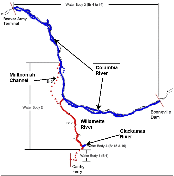
Figure 2. Conceptual Layout of the Lower Willamette River
System Model (Points Represent Model Segments)