Effects of Inter-annual and Decadal-scale Climate Variability on Winter and Spring Streamflow in western Oregon and Washington
by
Roy W. Koch and Austin R. Fisher
Department of Civil Engineering and Environmental Sciences
Portland State University
ABSTRACT
River basins in western Oregon and Washington that have a seasonal snowpack exhibit a dual-peaked hydrograph. The early peak is due to the winter maximum rainfall occurring at lower elevations and the later one is due to snowmelt. Three such basins were examined to determine whether the distribution of streamflow within the year is related to indices of either inter-annual (as measured by the Southern Oscillation Index, SOI) or inter-decadal (as measured by the Pacific Decadal Oscillation, PDO) variability in the climate. The relationship of streamflow to SOI is affected by the phase of the PDO. During below average phases of the PDO (generally warm SST’s in the north Pacific Ocean, except along the North American coast), streamflow exhibits a significant relationship to SOI, where as during the above average phase, there is no statistically significant relationship between streamflow and SOI. Statistically significant differences in the distribution of flow within the year were also noted and were related to the phase of the PDO.
INTRODUCTION
Streamflow in the western US is largely due to the accumulation of a seasonal snowpack over the winter months and the melting of this snowpack over the spring and early summer. This pattern in snow accumulation and melt recharges the hydrologic system producing a characteristic hydrograph of high flows in the late spring and early summer that recedes through the summer. A variation of this pattern occurs in the area of western Washington, Oregon and northern California, in particular in rivers along the Western slopes of the Cascade Mountains. In this region, mild temperatures at the lower elevations combined with the high winter-season precipitation produce a dual peaked hydrograph. High streamflow occurs in the winter months (typically November through January) due to high precipitation occurring as rain in the lower elevations and again in the late spring and early summer (typically March through June) due to snowmelt.
Volume forecasts of streamflow are an important component to water management across the western US. They are used to plan water use and to develop operating strategies for reservoirs that provide water supply and flood control, among other uses. These forecasts represent an estimate of the range of total flow expected to occur over a particular period or time, and are based largely on measurements of snow water equivalent at selected points in the basin, representing the moisture that is available for runoff. However, in the western portion of the Pacific Northwest, a substantial part of the total flow occurs during the winter months as a result of rainfall at lower elevations. Since forecasts commence in January each year and are primarily based on snow water equivalent, the volume forecasting procedures currently in place do not capture this early portion of the flow. Although procedures are being implemented by the National Weather Service River Forecast Centers that forecast the entire hydrograph, most forecasts are currently restricted to the seasonal volume and no information is provided regarding how this volume will be distributed through the runoff season. An estimate of the distribution of flow would be particularly useful in reservoir operation decisions. Understanding the variability of streamflow in this region, including the total volume of flow to be expected and the timing of flow during the winter, spring and early summer is a first step toward extending current forecast procedures.
A major aspect of variability in streamflow is the variability of regional climate, which, in turn, is related to larger scale phenomena occurring in the oceans and the atmosphere. Over the past two decades, research on the relationship of large scale climate features to regional climate and hydrology has produced an understanding how at least one feature, the El Niño-Southern Oscillation (ENSO), is related to the climate and streamflow in much of the US and other parts of the world (e.g. Koch et al, 1991, Redmond and Koch, 1991, Cheiw et al, 1998). The ENSO phenomenon has been shown to influence the inter-annual variability of regional climates in many parts of the world and has become an important component in both climate and hydrologic forecasting procedures. In some cases, particularly in parts of the western US, the ENSO is an important predictor of winter climate and therefore of the amount of streamflow to be expected from that moisture source.
Recently, another phenomenon, the Pacific Decadal Oscillation (PDO), has been observed that exhibits decadal-scale variability (Mantua et al, 1997). The PDO, described in more detail in the next section, is an index of the sea surface temperature in the north Pacific Ocean. Recent studies (Mantua et al, 1997, McCabe and Dettinger, 1998) suggest that the PDO is also related to regional climates as well, at least in the western US and Canada. In addition, these studies also observe an interaction between the ENSO and PDO phenomena.
In this study we inquire whether the variability observed in the streamflow record, both from year to year and within the year, is related to these large-scale features in the ocean and atmosphere for three-river basins in Oregon and Washington. We first describe two of the dominant features in the global climate system that have been observed to affect the surface climate and hydrology of the Pacific Northwest; the well known ENSO phenomenon and the more recently observed Pacific Decadal Oscillation. We proceed to show at least one way that these two phenomena interact, how that interaction is manifest in seasonal streamflow volumes and the implications of that interaction on seasonal volume forecasting. We then investigate the effect of these large-scale climate features on the distribution of streamflow throughout the year. Finally, we discuss the implications of these results and how they will be used in subsequent work to develop forecasting models of monthly flow sequences.
THE ENSO AND PDO PHENOMENON
In this study we use two indices of large-scale climate, one related to the ENSO and the other to the PDO. These indices capture the behavior of phenomena that occur over large spatial scales in a single numerical value that can be used to represent the variation of the phenomena over time and their relationship to other variables of interest; in this case, streamflow.
The El Nino-Southern Oscillation
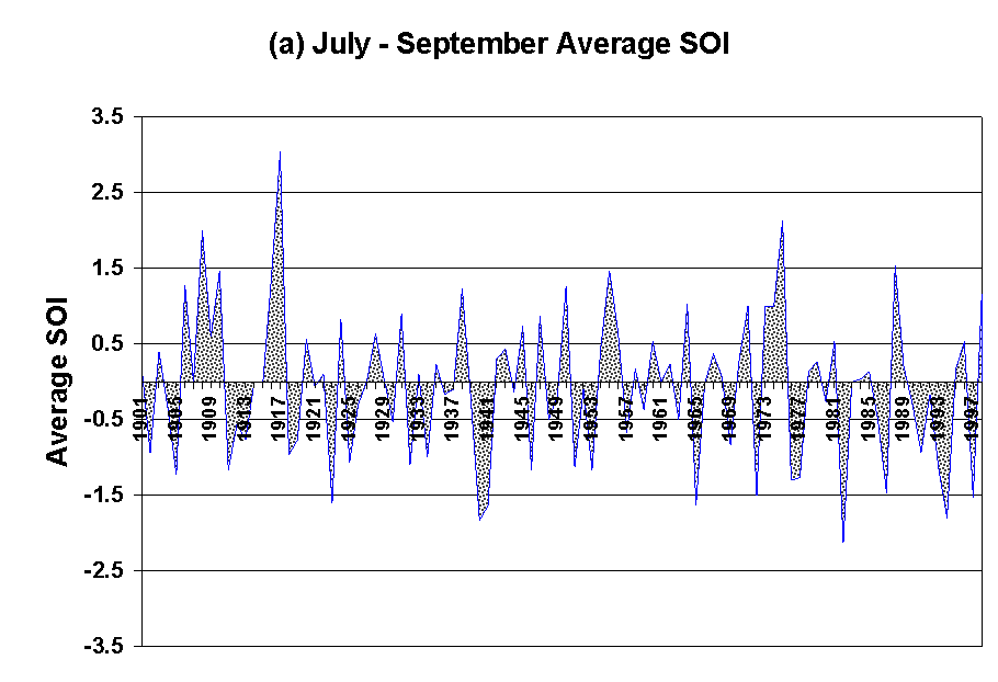
The ENSO has been studied extensively and has been well documented, particularly since the very large event that occurred in 1982-83. This phenomenon is defined by variations in sea surface temperature, atmospheric pressure and circulation in the tropical Pacific Ocean. Under conditions associated with average sea surface temperature and circulation conditions, SST’s along the equator range from cool in the eastern Pacific off the coast of South America to warm in the western Pacific. Associated with this distribution of ocean temperature is a high-pressure center located near the eastern end and a low-pressure center in the west. Surface winds are from east to west, rising by convection over the western end and returning to the east in the upper atmosphere, forming the so called Walker cell. During El Niño conditions, the temperatures in the eastern Pacific are anomalously high, surface pressure is low and the circulation pattern is depressed, and in some extreme cases, reversed. Conversely during a La Niña, SST’s in the eastern Pacific are below normal and the pressure gradient and associated circulation pattern is intensified. An index of this behavior based on atmospheric pressure is the Southern Oscillation Index (SOI), a standardized measure of difference in sea level pressure between Tahiti, located near the eastern end and Darwin, Australia in the west. El Niño events are characterized by strongly negative values of the SOI while La Niña events are characterized by strongly positive values. Variability of this phenomenon is on an inter-annual time scale with anomalous SST’s and atmospheric pressure persisting on the order of one year, more or less. A time series of the SOI for approximately the last century is shown in Figure 1a showing the inter-annual variability of the index.
In numerous studies over the past two decades, the ENSO phenomenon has been shown to be a major contributor to climate variability in many regions of the world. These teleconnections have been documented for various regions in North America and significant connections have been noted in the Pacific Northwest and desert Southwest (Redmond and Koch, 1991).
The Pacific Decadal Oscillation
The PDO has been more recently observed and described, originally in connection with the study of Alaska salmon production and its relationship to climate and ocean conditions (Mantua, 1999). This phenomenon is defined by SST and pressure variations in the northern Pacific Ocean. Unlike the ENSO which varies more or less annually, PDO events are characterized by persistence over 20 to 30 years (Mantua, 1999). The PDO has been described as having a warm phase, characterized by generally below average SST’s in the north Pacific with anomalously high SST’s off the coast of North America. The opposite occurs during the cool phase of the PDO.
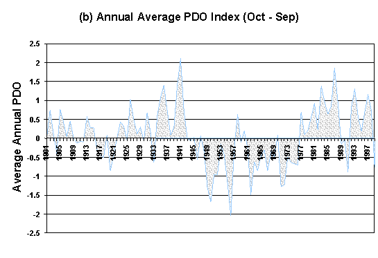
The inter-decadal character of the PDO is captured in an index, also called the PDO, that is the leading principal component of SST’s in the Pacific Ocean north of 20oN latitude (Mantua et al, 1997). A time series of the PDO, shown in Figure 1b. The striking feature in this time series is the consistent behavior of this index, at least in terms of sign, over periods up to 30 years in duration. Mantua et al (1997) have identified four periods of consistent PDO behavior using intervention analysis. These periods are characterized by a PDO of predominantly the same sign. Shifts in the PDO were identified in 1925, 1947 and 1977.
Recent studies suggest that the climate of North America is also related to the PDO and that ENSO influences on climate may be affected by the PDO (e.g. McCabe and Dettinger, 1998).
Figure 1: Time series of (a) the SOI averaged over July - September and (b) the PDO averaged over the water year (October to September) from 1901 to 1998).
DATA AND METHODOLOGY
Three river basins were selected for this study. They are all located along the western slopes of the Cascade Mountains in Oregon and Washington and represent a north-south transect. From north to south the basins are those drained by the Skykomish, Sandy, and Rogue Rivers, respectively. The location of each basin can be seen in Figure 2. These basins were selected to provide some spatial variation from north to south and for the length of available record, absence of upstream diversions, and for their location in the western Cascade Mountains.
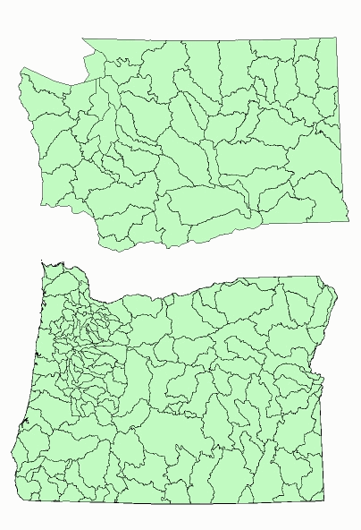
Figure 2: Location of the Skykomish, Sandy, and Rogue rivers in Washington and Oregon states.
Data
In this study, data describing both streamflow and the two important features in the global climate, ENSO and the PDO, were required. Monthly streamflow data were collected for the three river basins identified previously The longest period of record is the Sandy River, which is continuous since 1920 with additional data from 1912 – 1915 and 1917 – 1918. The largest drainage basin is the Skykomish River at 1,386 km2, which is located east of Seattle in Washington. The Sandy River basin is located east of Portland, Oregon and drains 681 km2. Finally, the Rogue River basin is located in Southern Oregon and drains 808 km2.
Table 1: Summary of data used in the study
|
Station/Data |
USGS Station Number |
Period of Record |
Drainage Area (km2) |
Missing data |
HUC |
Elevation (m ab. NGVD) |
Average Annual Flow (m3/s) |
|
Skykomish |
12134500 |
1929-98 |
1386 |
none |
17110009 |
232 |
112 |
|
Sandy |
14137000 |
1912-98 |
681 |
1916, 1919 |
17080001 |
223 |
38 |
|
Rogue |
14328000 |
1924-98 |
808 |
none |
17100307 |
799 |
23 |
|
SOI1 |
1882-98 |
||||||
|
PDO2 |
1900-98 |
1
Available at http://www.cpc.ncep.noaa.gov2
Available at ftp://ftp.atmos.washington.edu/mantua/pnw_impacts/INDICES/PDO.latestThe SOI was used as a measure of ENSO activity. Monthly data on the SOI are available on the web at the address referenced in the footnotes of Table 1. The Pacific Decadal Oscillation (PDO) measures the decadal scale variability in the north Pacific Ocean and is available at the ftp address also referenced in Table 1. Descriptions of both indices are also available at the respective web sources.
Analysis methods
Since this study is largely exploratory, seeking to discover what relationships exist between the selected indices of large-scale climate and local streamflow, the methods are entirely statistical. Correlation coefficients are computed between the large-scale climate indices, averaged over selected months, and seasonal averaged streamflow are used to identify the relationships. These correlations are computed for various times and can be represented as:
r(k)=corr[Q,x(k)]
In this equation, r(k) is the correlation coefficient between the seasonal streamflow, Q, and x(k) is the averaged value of the index with the averaging beginning in month k. Using this approach, the relationship between streamflow and the various indices can be evaluated as it changes over time.
The second technique used to identify relationships between of the distribution of streamflow within the year and climate indices is the composite hydrograph. Using monthly data, hydrographs were constructed as average of flow in each month throughout the year, for defined climatic conditions. A comparison of these composite hydrographs for different climate conditions reveals any differences in the distribution of flow within the year in relation to the climate indices.
RELATIONSHIPS OF ENSO AND PDO TO SEASONAL STREAMFLOW
Even though a continuous record of climate indices is available to represent both the ENSO (i.e. the SOI) and the PDO, preliminary analyses and a consideration for the nature of the PDO suggested an analysis based on splitting the streamflow record based on PDO phases. In all subsequent analyses, the streamflow record at each location is split based on the PDO periods identified by Mantua et al (1997). The streamflow used for the analyses is the flow occurring between November and June, resulting from the winter precipitation either directly or as a result of accumulation and melting of the snowpack.
Effects of PDO phase on SOI-streamflow relationships
Streamflow is related to ENSO in much of the Pacific Northwest as has been demonstrated in a number of studies (e.g. Koch et al, 1991). In general, following the relationships between ENSO and precipitation, streamflow in the Pacific Northwest tends to be below average during El Niño events and above average during La Niña events. The first analysis focused on determining whether those relationships were affected by the phase of the PDO and if so, in what way. Pearson’s correlation coefficient was computed for seasonal (November through June) streamflow in each basin and successive values of 3-month averaged SOI beginning the previous April. This computation was performed for the entire streamflow record and for the record split into periods when the PDO was in either the low or high phase. The results of these analyses for all three basins are shown in Figure 3.
The results are consistent at each location. Using the entire period of record, moderate correlations are observed for the Skykomish and Sandy Rivers as much as 3 months prior to the beginning of the seasonal volume with low and generally statistically insignificant correlations observed for the Rogue River. In all cases, positive correlations result, indicating generally lower streamflow during El Niño periods for the region. This is also consistent with earlier work where stronger correlations were observed in the northern portions of the region. When the sample is split by PDO phase, the correlation of SOI with seasonal streamflow increases for the low PDO phase and decreases for the high PDO phase. Most remarkable is the Rogue River where a statistically significant relationship is now observed for the low PDO phase. With the exception of the very early months preceding the runoff season in the Skykomish, correlations between SOI and seasonal streamflow during the high PDO phase is statistically insignificant. In each case, the strongest correlation during the low PDO phase occurred with SOI averaged over the August to September period.
RELATIONSHIPS OF ENSO AND PDO TO THE DISTRIBUTION OF SEASONAL STREAMFLOW
It is clear that the PDO affects the relationship between seasonal streamflow and SOI in the three basins under consideration. It is then reasonable to ask whether the ENSO, PDO or both also affect the distribution of the seasonal volume as represented by the monthly streamflow. To first understand how both ENSO and PDO affect the distribution of flow, composites of monthly flow were constructed for the four combinations of low and high PDO and El Niño and La Niña conditions. In undertaking this analysis, the objective was to identify whether there were similarities in the shape of the composite hydrographs for a particular climate state, e.g. the particular PDO or ENSO phase. The thinking here was as follows. If there is a typical climate response associated with a particular climate state, then the shape of the hydrograph, e.g. timing of the peaks and their relative magnitudes, might be distinctive as well.
The composite hydrographs for each basin are presented in Figure 4. Although somewhat confused, at least a few observations can be made from these graphs. First, it is clear that for all three basins the highest flows, in aggregate, occur during a combination of La Niña and low PDO. In addition, under these conditions, there is a noticeably higher peak in the winter months. Under these circumstances, generally cold ocean conditions exist in both the equatorial ocean and the western north Pacific Ocean. No other consistent responses are obvious from these composite hydrographs.
As an alternative approach to determine whether a difference exists in the average distribution of streamflow throughout the year, the fraction of flow occurring in each month in relation to the annual flow was computed using the split sample based on PDO phase. The resulting fractional hydrographs for each basin are presented in Figure 5. The differences in the hydrographs are not striking but there are some differences in both timing and proportions. For the Skykomish River, a smaller fraction of flow occurs in the winter as opposed to the spring for low PDO conditions and the peak flow month is later. For the Sandy River, a higher proportion of the flow can be expected in the winter during low PDO conditions and, like the Skykomish, the Spring peak occurs one month later. There are no obvious differences in timing of flow for the Rogue River. No apparent differences occurred when monthly streamflow was composited in a similar way by El Niño and La Niña events.
To determine if the observed differences in these hydrographs have statistical significance, a rank sum test (Helsel and Hirsch, 1992) was performed on the fractions for each month at each site. The results of the test, presented in Table 2, indicate that there are differences in the fraction of flow for particular months for all of the river basins. The differences apparent in the fractional hydrographs do not all pass statistical tests while several differences that are not obvious are statistically significant, particularly for the Rogue River.
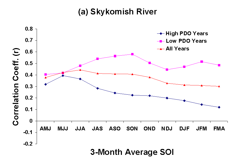
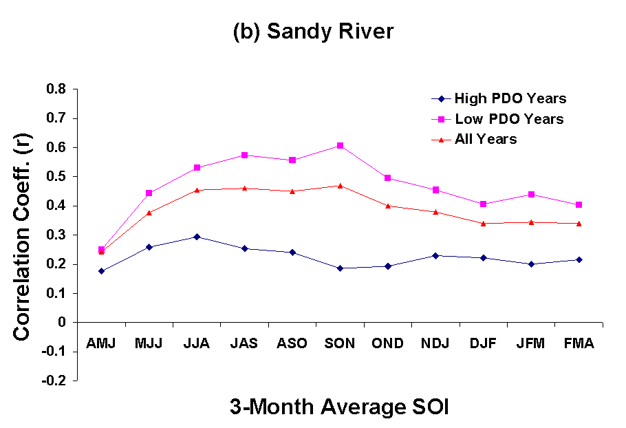
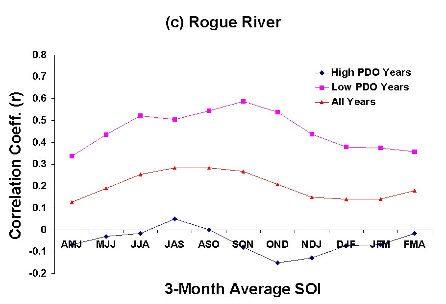
Figure 3: Correlation of 3-month average SOI and November to June streamflow in (a) the Skykomish, (b) Sandy, and (c) Rogue rivers.
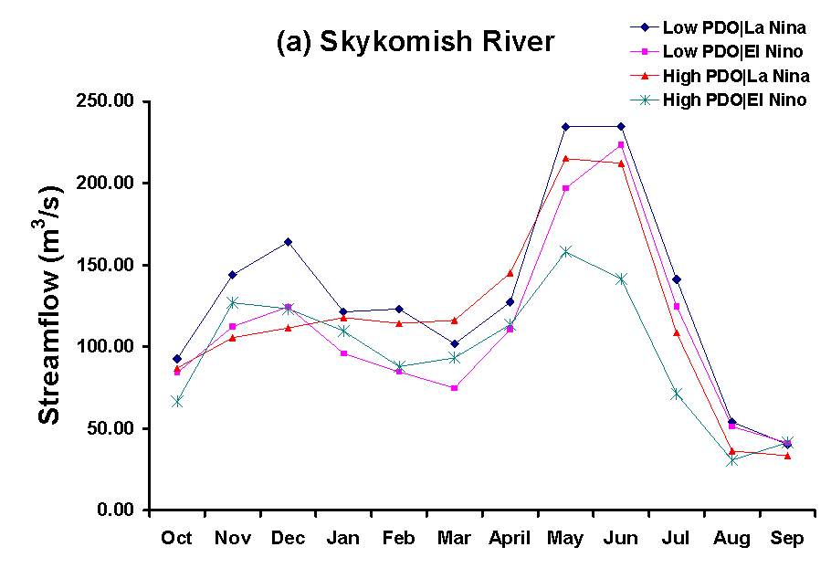
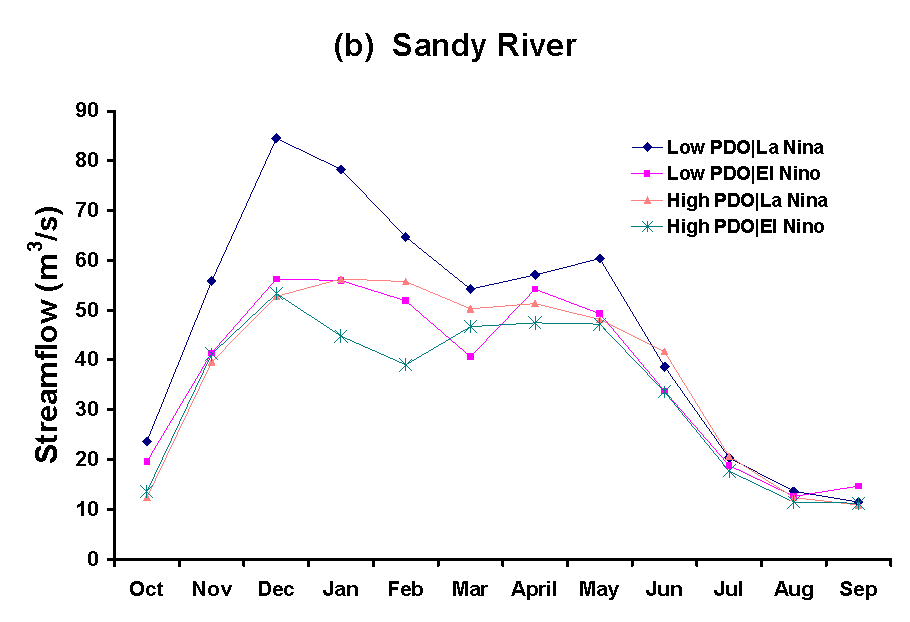
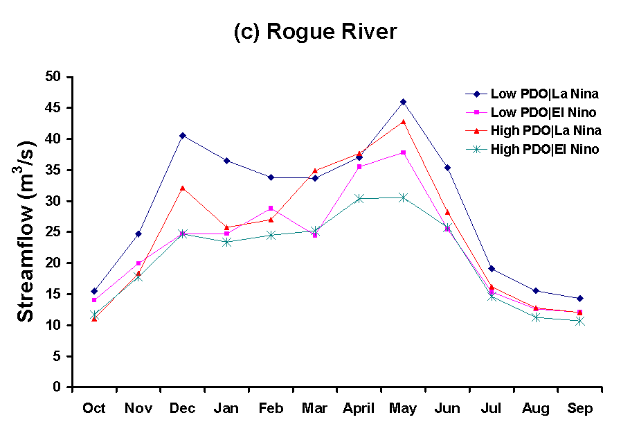
Figure 4: Composite monthly hydrographs based on PDO and ENSO for (a) the Skykomish, (b) Sandy, and (c) Rogue rivers.
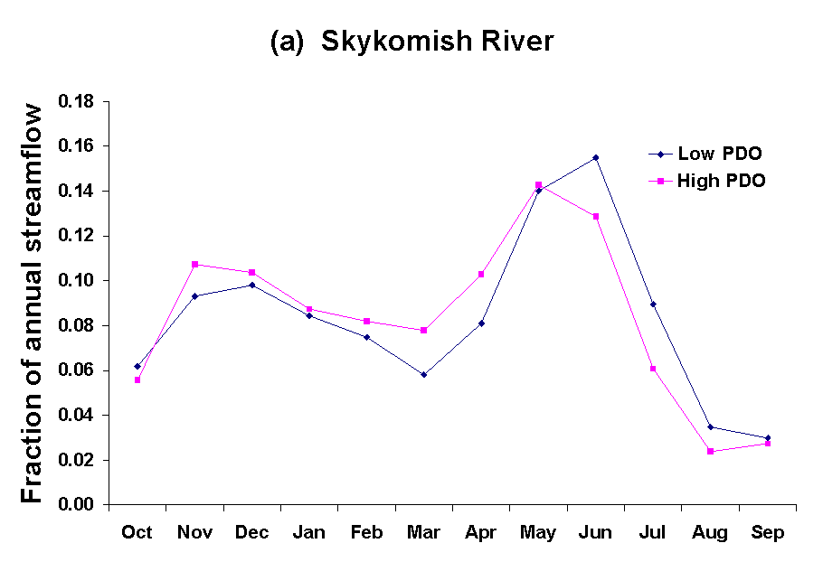
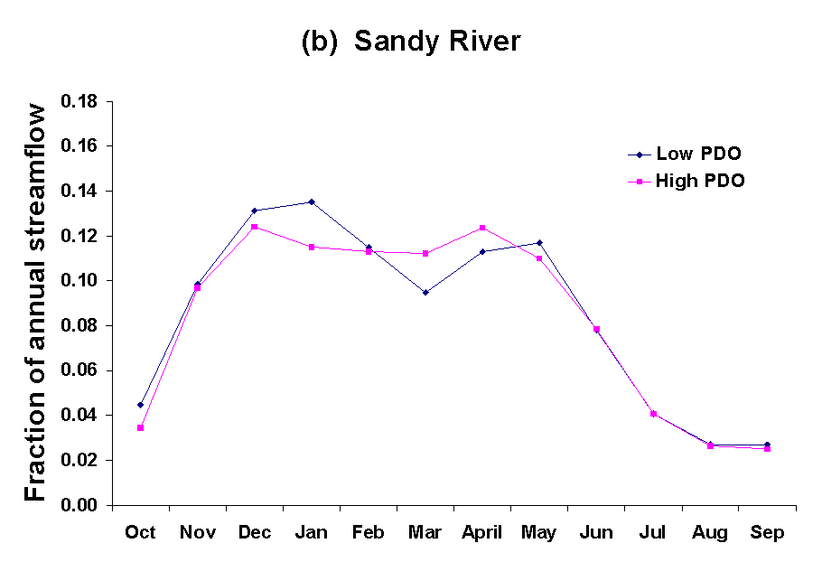
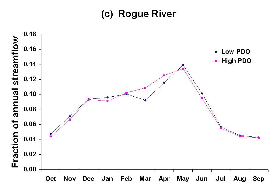
Figure 5: Composite monthly fractions based on PDO for (a) the Skykomish, (b) Sandy, and (c) Rogue rivers.
Table 2. p values for rank-sum tests on the fraction of flow occurring in each month for low and high PDO conditions. Values in bold are significantly different at the 5% level and values in italic at 10%.
|
Month |
Skykomish |
Sandy |
Rogue |
|
Oct |
0.08 |
0.03 |
0.26 |
|
Nov |
0.80 |
0.75 |
0.20 |
|
Dec |
0.83 |
0.40 |
0.70 |
|
Jan |
0.99 |
0.10 |
0.97 |
|
Feb |
0.74 |
0.61 |
0.97 |
|
Mar |
0.00 |
0.01 |
0.01 |
|
Apr |
0.00 |
0.07 |
0.04 |
|
May |
0.53 |
0.59 |
0.43 |
|
Jun |
0.01 |
0.72 |
0.28 |
|
Jul |
0.00 |
0.28 |
0.87 |
|
Aug |
0.00 |
0.93 |
0.07 |
|
Sep |
0.21 |
1.00 |
0.50 |
FURTHER COMMENTS AND IMPLICATIONS FOR FORECASTING
An analysis of streamflow for three river basins in western Oregon and Washington shows that the amount of seasonal streamflow occurring in the winter and spring as a result of winter precipitation, is related to the SOI, a measure of the El Niño/La Niña phenomenon. However, the relationship is variable and not statistically significant for the Rogue River, the southern-most basin in the study. Further analysis indicates that the seasonal streamflow-SOI relationship varies depending on the phase of the PDO, a decadal-scale mode of variability. Construction of composite monthly hydrographs suggests that there are clear differences in the hydrograph depending on both the SOI and the PDO. For all of the basins, the highest flow was observed for La Niña events occurring when the PDO was in the low phase. There were some differences noted in the monthly hydrograph when composites were constructed for low and high PDO phases. No systematic differences were noted for composites constructed for El Niño and La Niña periods.
By way of comparison, the analysis of seasonal flow and its distribution within the year was also conduced for the Salt River basin in Arizona. The results were consistent (but inverse) with those discussed above for the streamflow-SOI relationships. In addition, differences in the monthly hydrographs were more consistent than those observed in western Oregon and Washington when composites were constructed based on PDO. The peak flow month was consistently shifted depending on PDO phase, regardless of whether an El Niño and La Niña occurred.
The potential exists for this work to contribute to improvements in water supply forecasting. During low PDO periods, the utility of the SOI as a variable in forecasting improves markedly for all cases evaluated. This result implies that there is the possibility to forecast not just streamflow resulting from snow accumulation and melt but also the portion of the hydrograph due to rain, thus expanding the forecast capability. On the other had, the SOI is apparently not useful in forecasting when the PDO is in the high phase. In both cases, that is for low and high PDO, a better estimate of the uncertainty of forecasts would result based on this information. Finally, an understanding of differences in the monthly distribution of seasonal flow is useful for the operation of reservoirs, and potentially for other purposes. This work is being used as the basis for the development of conditional disaggregation models, that is models that will distribute the seasonal flows throughout the season as monthly flows. If the typical distribution were different for low vs. high PDO, a different model would be required.
A forecasting procedure is now being developed and tested based on the results. The process is as follows:
This approach will be tested against the current approach of a single volume forecast equation and standard disaggregation procedures to determine if it provides improved information for reservoir operation.
ACKNOWLEDGEMENTS
This work was supported, in part, by a grant from the U.S. Geological Survey, for a project entitled Decision Support System for River System Management Under Hydroclimatic Uncertainty, Juan Valdes, Principal Investigator. The project is a collaborative effort of students and faculty at the University of Arizona, The University of California at Santa Barbara and Portland State University.
REFERENCES
Cheiw, F.H.S., Piechota, T.C., Dracup, J.A. and T.A. McMahon. (1998) El Niño/Southern Oscillation and Australian rainfall, streamflow and drought: links and potential for forecasting, Journal of Hydrology, Vol. 204, No. 1-4, pp. 138-149.
Helsel, D. and Hirsch, R.M. (1992) Statistical methods in water resources. Elsevier Science, Amsterdam
Koch, R.W., C.F. Buzzard and D.M. Johnson. (1991) Variation in snow water equivalent and streamflow in relation to the El Niño/Southern Oscillation, Proceedings of the Western Snow Conference, Juneau, Alaska, pp. 37-48.
Mantua, N.J., Hare, S.R., Zhang, Y., Wallace, J.M., and R.C.Francis. (1997) A Pacific inter-decadal climate oscillation with impacts on salmon production. Bulletin of the American Meteorological Society, 78(6),pp. 1069 -1079.
Mantua, N.J. (1999) The Pacific Decadal Oscillation, to appear in the Encyclopedia of Global Environmental Change (available at www.atmos.washington.edu/~mantua/REPORTS/PDO/PDO_egec.htm).
McCabe, Gregory, and Michael D. Dettinger. (1998) Decadal variability in the strength of ENSO teleconnections with precipitation in the Western United States. PACLIM Conference Proceedings, pp. 69-78.
Redmond, K.T. and R.W. Koch. (1991) Surface climate and streamflow variability in the Western United States and their relationship to large-scale circulation indices. Water Resources Research, 27(9), pp. 2381-2399.